


You’ve been flying manual lawnmower grids for three months. Your arm is tired. Your overlaps are inconsistent — 72% on one pass, 64% on the next. You reset your flight path three times because the wind pushed you 15 ft (4.5 m) off your planned line. The orthomosaic came back with a seam. You’re asking yourself: there has to be a better way.
There is. Automated waypoint missions cut the guesswork. Plan once on your desktop. The drone flies the same grid every time — overlap locked at 75%, battery usage predictable, results reproducible.
The catch: DJI’s Mini 3/Mini 3 Pro/Mini 4 Pro have limited SDK support. DJI’s own mobile app has a basic waypoint mode, but it’s missing grid planning tools. Third-party apps — Litchi Pilot, DroneLink, and WaypointMap — each solve the problem differently. Here are the tradeoffs and which one to pick.
The fundamental constraint you need to understand first: DJI’s Mobile SDK v5 (MSDK v5), which added Mini 4 Pro support on March 17, 2025, is Android-only by DJI’s architectural decision. Every third-party app that directly controls the Mini 4 Pro requires an Android device and the RC-N2 controller (the one with the phone clamp, not the built-in screen). If you have an iPhone or the RC 2 controller (built-in screen), your only automation option is the KMZ workflow: plan your mission in a web tool like WaypointMap, export a .kmz file, and load it into DJI Fly for execution. This is a hardware limitation, not a software one — no app can work around it.
Why Automate Your Flights
Manual grid flying has gotten you this far. Here’s what changes when you automate.
Consistency. Hand-flying means every flight is slightly different — you correct for wind, adjust altitude mid-mission, eyeball overlap. Automated missions fly the same path every time. Same waypoints, altitude, speed, camera triggers. That translates directly to more uniform overlap and cleaner orthomosaics.
Repeatability. Fly the same site on different days and get datasets that stack. Point clouds from Week 1 and Week 3 align better when both used identical flight parameters. That matters for change detection, progress monitoring, and time-series work.
Battery efficiency. No course corrections means no wasted battery. On a 45-acre site, expect 10-15% less flight time than manual grids.
Reduced workload. Hand-flying a 25-minute grid is cognitively demanding — heading, altitude, speed, coverage, battery, all at once. Automated missions free you up to monitor from the ground, swap batteries, or prep the next site. On a full day of multisite jobs, that adds up fast.
Easier client hand-offs. Client says “map that again next month”? Load your saved mission file. Same parameters, same results.
The DJI Mini SDK Problem
DJI’s Mobile SDK (MSDK) — the toolbox third-party developers use to build apps — has incomplete support for the Mini series.
The Mini 3, Mini 3 Pro, and Mini 4 Pro are DJI’s volume products. They’re also stripped-down versions of the Air/Pro lines. They share the Intelligent Flight Battery but use a different onboard processor. This difference means:
- Full MSDK access: Air 2S, Air 3, Mavic 3, Pro Cine — developers can access all flight parameters, camera settings, and automation hooks.
- Partial MSDK: Mini 3/3 Pro/4 Pro — developers can plan waypoints and trigger cameras, but some parameters are locked or unavailable.
The Android-only constraint. DJI released MSDK v5 support for Mini 4 Pro on March 17, 2025. MSDK v5 is Android-only — DJI made an architectural decision not to support iOS. This means every third-party app that directly controls the Mini 4 Pro (Litchi Pilot, DroneLink, Map Pilot Pro) requires an Android device and the RC-N2 controller (phone clamp model). The RC 2 (built-in screen) cannot run third-party MSDK apps. iOS users and RC 2 users must use the KMZ workflow — plan in a web tool, export .kmz, execute via DJI Fly.
What gets locked out even on MSDK v5? Usually the nuanced stuff: precise gimbal control mid-flight, terrain-follow mode, wind-resistance compensation, custom camera trigger patterns. The basic grid mission still works — you can fly predetermined waypoints and take photos at intervals.
For mapping, this is mostly fine. You don’t need terrain following for flat farmland or rooftops. You don’t need gimbal tricks. You need: a grid pattern, consistent overlap, and reliable camera triggers.
The real limit: app developers have to work within DJI’s SDK constraints. No new app can solve limitations that DJI’s MSDK doesn’t expose.
Third-party apps for Mini mapping exist and stay updated, but they work within tighter constraints than Air/Mavic equivalents. A feature on the Mavic 3 version won’t necessarily exist for the Mini. Plan for that gap.
Litchi Pilot — Free Beta (Android + RC-N2 Only)
Important distinction: The standard “Litchi for DJI Drones” app ($25) does not support the Mini 4 Pro. For Mini 4 Pro, you need Litchi Pilot — a completely separate app built on DJI’s MSDK v5. Litchi Pilot is currently in free open beta (Android only, RC-N2 controller required). Final pricing is TBD. Do not buy the original Litchi app expecting Mini 4 Pro support — it won’t work.
Litchi Pilot brings the familiar Litchi mission planning workflow to MSDK v5 drones including the Mini 4 Pro. It’s a ground-up rebuild, not a port of the old app.
What Litchi Pilot Gives You
Desktop mission planner. Open Litchi’s web-based Mission Hub on your laptop, drag-and-drop waypoints on a map, set parameters, and save. Way faster than phone apps — you can zoom in, measure distances, and place waypoints precisely.
Grid mission generator. Input your survey area (as a polygon), set your desired overlap percentage (75%), altitude, and flight speed. Litchi Pilot calculates the grid pattern and waypoints instantly. Review, adjust if needed, download to your phone.
Overlap calculator. Input altitude, drone model, and desired ground sample distance (GSD). Litchi Pilot calculates overlap percentage and suggests flight parameters. For Mini 4 Pro at 200 ft (61 m) in 12 MP mode, you’ll get ~2.2 cm GSD with 75% overlap. (Cross-reference with the GSD Calculator for precise values.)
Camera trigger control. Set exact trigger intervals or distance-based triggers — every 2 seconds, every 30 meters of travel, or both (stricter wins). This is what keeps your overlap consistent.
Terrain follow mode. Available on some drones; limited on Mini series. Useful if your site has significant elevation changes. The drone maintains constant altitude above ground rather than constant absolute altitude.
Platform requirements: Android only. RC-N2 controller required (phone clamp model). No iOS support. No RC 2 support.
Supported drones: Mini 4 Pro, Mini 3 Pro, plus other MSDK v5 drones (Air 3, Mavic 3 series).
Workflow: Litchi Pilot for a Real Job
Say you’re mapping a 5-acre (2 ha) property.
-
Plan on desktop. Open Litchi Mission Hub. Load a satellite image of your site. Outline the area with waypoints. Set altitude to 150 ft (46 m), overlap to 75%, flight speed to 3 m/s. Litchi Pilot generates 47 waypoints in a 4x12 grid pattern. You review the grid — does it hit all the corners? Any blind spots? Adjust if needed.
-
Download to your Android phone. Export the mission from Hub. Import it into the Litchi Pilot app.
-
Fly. Connect your Mini 4 Pro via the RC-N2 controller and Litchi Pilot app. Launch the mission. The drone ascends to 150 ft, moves to the first waypoint, and starts the grid. You watch from below. The app shows the drone’s position, battery status, and current waypoint number.
-
Camera trigger. Litchi Pilot sends camera trigger signals every 2 seconds (or your set interval). The Mini 4 Pro’s camera fires each time. No manual button pressing.
-
Landing. After the grid completes, Litchi Pilot executes your return-to-home command. The drone descends to your launch point.
-
Images in hand. Download the image files from your SD card. You have 200+ images with consistent 75% overlap, ready for processing.
Litchi Pilot Pros
- Currently free. Open beta — no cost while in beta.
- Desktop planning. Mission Hub is faster than phone planners — better context, precise control.
- Grid automation. 30 seconds from area outline to perfect grid.
- Litchi heritage. Built by the same team behind the original Litchi (since 2012). Flight execution expertise carries over.
- Active community. Reddit, forums, YouTube tutorials. Some original Litchi resources still apply.
- Works offline. Plan on desktop, fly without internet in the field.
Litchi Pilot Cons
- Android only. No iOS support. This is a DJI MSDK v5 limitation, not a Litchi decision.
- RC-N2 required. Won’t work with the RC 2 (built-in screen) controller. You need the phone-clamp controller.
- Beta software. Expect occasional bugs. Not as polished as the original Litchi app.
- Pricing unknown. Currently free, but final pricing is TBD. Could match the original $25 or adopt a different model.
- Limited terrain follow. Mini series support is basic — useful for slopes, not steep terrain.
- No real-time grid adjustment. Once flying, you can’t adjust waypoints on the fly. Coverage gap? Land, replan, restart.
- Camera control limits. Mini doesn’t expose all camera parameters via MSDK. Trigger shutter and focus work; gimbal angle and advanced exposure don’t.
Cost
Free (open beta). Final pricing TBD.
DroneLink — $0-30/Month, Web-Based and Cloud (Android + RC-N2 Only)
DroneLink is a newer entrant with a different philosophy: cloud-first planning and a freemium pricing model.
Platform caveat: DroneLink’s Mini 4 Pro support requires Android + RC-N2 controller. No iOS support. The APK must be sideloaded (not available on Google Play). No RC 2 controller support. Same MSDK v5 constraint as Litchi Pilot.
What DroneLink Gives You
Free tier: Cloud-based mission planning (web only, no install). Grid mission generator for Mini series. Unlimited mission storage. Basic camera triggering.
Paid tier ($9.99/mo Standard, $29.99/mo Enterprise): Real-time flight monitoring and analytics. Cloud-backed flight logs. Detailed mission performance reports. Priority support.
Mobile app. Android app syncs with your cloud missions. No USB cable, no file imports — your missions appear in the app automatically. APK sideload required for Mini 4 Pro support (not on Google Play).
Grid mission generator. Same concept as Litchi Pilot — outline area, set overlap, get waypoints. No desktop planner; it’s all web-based.
Supported drones: Mini 3, Mini 3 Pro, Mini 4 Pro (Android + RC-N2 only). Also Air 2S, Air 3, Mavic 3.
DroneLink Pros
- Free tier. Mission planning alone costs nothing.
- Cloud-based. No install for planning — works on any browser.
- Sync across devices. Plan on laptop, fly from Android phone, no file transfers.
- Integrated analytics. Paid tier includes flight logs, coverage reports, performance dashboards.
- Simpler interface. Fewer buttons than Litchi Pilot — better for beginners.
DroneLink Cons
- Android + RC-N2 only. No iOS. No RC 2 controller. Same MSDK v5 constraint as every direct-control app.
- APK sideload required. Not on Google Play for Mini 4 Pro support. Extra setup friction.
- Limited grid control. Less configurable than Litchi Pilot. Post-generation waypoint adjustments are clunky.
- Paid tier adds up. $9.99/month x 12 = $120/year.
- Less mature execution. Flight execution is reliable, but no 12-year track record like Litchi.
- Smaller community. Fewer tutorials, forum posts, and documented edge cases.
Cost
Free tier: $0/month (grid planning, mission storage, basic flying). Standard: $9.99/month (analytics, cloud storage, priority support). Enterprise: $29.99/month (team sharing, advanced analytics).
DJI Fly Waypoints — Free, Built-In, Severely Limited
DJI’s own Fly app includes a basic waypoint mode. It’s free. You own the drone already. Why not use it?
What DJI Fly Gives You
Basic waypoint planning. Tap on the map to place waypoints. The drone flies between them.
Manual camera triggering. You tap a button to take photos. Or set an interval (e.g., every 2 seconds) and let the app trigger.
No grid generator. You manually place every waypoint. For a 5-acre site, that’s 47 taps and drag operations. It’s tedious and error-prone.
No overlap calculator. You have to manually estimate: “At 150 ft altitude, with what interval should I trigger to get 75% overlap?” This isn’t obvious.
No terrain follow. Just flies to fixed altitudes.
DJI Fly Pros
- It’s free. You have it already.
- No learning curve. You use it to fly your Mini every day anyway.
- Official support. DJI maintains this app; it updates with OS improvements.
DJI Fly Cons
- No grid automation. You place every waypoint manually. For anything bigger than a 1-acre site, this is painful.
- No overlap calculator. You guess trigger intervals. Your overlap is inconsistent.
- No pre-planning. You can’t plan the mission at home on a desktop. It’s all phone-based tapping.
- Mission persistence is weak. Saving and reloading missions is clunky. Exporting to .kmz works, but reimporting takes more steps than it should.
- No analytics. You get no feedback on flight performance, overlap achieved, or coverage gaps until you process the images.
Cost
Free. Built into DJI Fly.
WaypointMap — $15/Month or Free Tier, Works With Any Controller
WaypointMap is a web-based mission planning tool with a critical advantage: it generates KMZ files that DJI Fly executes. That means it works with the RC 2 controller (built-in screen) and on iOS — making it the only grid mapping option for users who don’t have Android + RC-N2.
For many Mini 4 Pro owners, WaypointMap is the most practical starting point.
What WaypointMap Gives You
Web-based grid planning. Open WaypointMap in any browser (desktop or mobile). Outline your survey area, set overlap and altitude, get a grid mission instantly.
KMZ export. WaypointMap generates .kmz waypoint files. Import these into DJI Fly’s waypoint mode. DJI Fly executes the mission — no third-party app controlling the drone directly.
Works with any controller. RC 2 (built-in screen)? Works. RC-N2 (phone clamp)? Works. iOS? Works. Android? Works. Because the flight execution happens through DJI Fly, not through MSDK, the platform and controller restrictions don’t apply.
Free tier available. Limited missions per month on the free tier. $15/month subscription for unlimited missions and full grid planning features.
Supported drones: Mini 3, Mini 3 Pro, Mini 4 Pro, Air 2S, Air 3, Mavic 3 — any drone that DJI Fly supports for waypoint missions.
WaypointMap Pros
- Works with RC 2. The only grid mapping option for RC 2 (built-in screen) users. This alone makes it essential.
- Works on iOS and Android. No platform restriction because DJI Fly handles execution.
- No sideloading. No APKs to install. Web browser + DJI Fly is all you need.
- Free tier. Try it before committing. $15/month is reasonable for active mapping.
- Simple interface. Fewer options than Litchi Pilot — fewer things to get wrong.
- Clear documentation. Site includes solid tutorials.
WaypointMap Cons
- Subscription model. $15/month x 12 = $180/year. Adds up for occasional users.
- KMZ workflow adds steps. Export, transfer, import, review — more friction than direct-control apps.
- Limited by DJI Fly. Your mission inherits DJI Fly’s limitations — no terrain follow, basic camera triggering, limited mission persistence.
- No real-time third-party monitoring. Once in DJI Fly, you get DJI Fly’s monitoring. No additional analytics.
- Smaller community. Growing but still less documented than Litchi.
Cost
Free tier: $0/month (limited missions). Subscription: $15/month (full grid planning, unlimited missions).
Map Pilot Pro & DroneDeploy — Brief Mention
Map Pilot Pro is a free app with split-platform support for Mini 4 Pro:
- Android APK: Direct drone control via MSDK v5. Requires RC-N2 controller. Full grid planning and autonomous flight execution. Free.
- iOS: Planning and KMZ export only. No direct drone control (MSDK v5 is Android-only). Plan your mission on iPad/iPhone, export .kmz, fly via DJI Fly. Free.
Map Pilot Pro is worth checking if you want a free alternative to Litchi Pilot (Android) or a free KMZ planner (iOS).
DroneDeploy is a cloud-based enterprise platform. Flight planning, execution, processing, client sharing. $99-$1,000+/month. Supports Mavic and Air. Mini support is limited.
For you: If you’re on Mini 4 Pro with Android + RC-N2, Map Pilot Pro is a viable free option alongside Litchi Pilot and DroneLink. DroneDeploy’s pricing doesn’t make sense for Mini-tier work.
Head-to-Head Comparison
Pick your row based on what matters most to you.
| Feature | Litchi Pilot | DroneLink | WaypointMap | DJI Fly |
|---|---|---|---|---|
| Cost | Free (beta, TBD) | $0-30/mo | $0-15/mo | Free |
| Platform | Android only | Android only | Any (web-based) | iOS + Android |
| Controller | RC-N2 only | RC-N2 only | RC-N2 or RC 2 | RC-N2 or RC 2 |
| How it flies | Direct MSDK control | Direct MSDK control | KMZ via DJI Fly | Built-in waypoints |
| Grid generator | Yes, configurable | Yes, basic | Yes, simple | No |
| Overlap calculator | Yes | Yes | Yes | No |
| Desktop planner | Yes (Mission Hub) | Web-based | Web-based | Mobile only |
| Camera trigger control | Interval & distance | Interval | Interval (via DJI Fly) | Interval |
| Terrain follow | Limited on Mini | Limited on Mini | No (DJI Fly limit) | No |
| Flight execution | Excellent (Litchi heritage) | Solid | Depends on DJI Fly | Solid |
| Cloud mission sync | Via Hub upload | Automatic | N/A (KMZ export) | Via .kmz export |
| Real-time analytics | Basic | Yes (paid) | No | No |
| Community size | Large | Small | Growing | N/A (DJI official) |
| Learning curve | Moderate | Low | Low | Low |
| iOS users? | No | No | Yes | Yes |
| RC 2 users? | No | No | Yes | Yes |
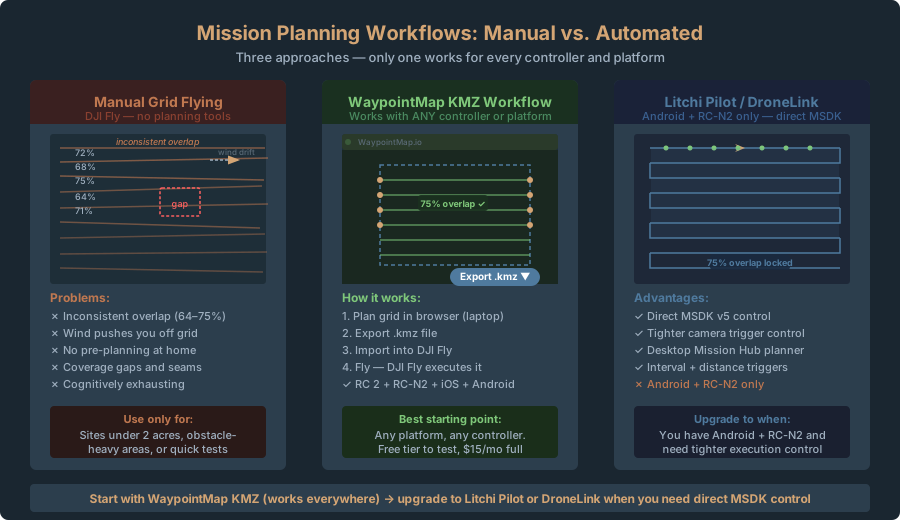
Recommended Workflow — Start With WaypointMap
Your best starting point depends on your controller and platform.
For everyone (any controller, any platform): WaypointMap.
-
Plan missions in your browser. Open WaypointMap on your laptop. Outline your survey area. Set altitude and overlap — use the GSD Calculator to dial in your parameters. Export the .kmz file.
-
Fly via DJI Fly. Import the .kmz into DJI Fly. Launch the mission. This works whether you have an RC 2 (built-in screen) or RC-N2 (phone clamp), and whether you’re on iOS or Android.
-
Why WaypointMap first: It works with every controller and every platform. No sideloading, no APKs, no Android requirement. For RC 2 users specifically, this is your only grid mapping option. The free tier lets you test before committing to $15/month.
For Android + RC-N2 users wanting more control: Litchi Pilot or DroneLink.
If you have an Android phone and the RC-N2 controller, you unlock direct MSDK control. Litchi Pilot gives you the best grid planning (Mission Hub desktop planner, interval + distance triggers, terrain follow). DroneLink offers a simpler cloud-based alternative. Both bypass DJI Fly’s limitations and give you tighter control over camera triggers and flight execution.
- Litchi Pilot for power users — configurable grids, desktop planning, Litchi’s 12-year heritage.
- DroneLink for simplicity — browser-based planning, cloud sync, lower learning curve.
- Map Pilot Pro as a free alternative — Android APK for direct control, iOS for KMZ planning.
Fallback: Manual grid flying.
If your site is small (under 2 acres), complex (lots of obstacles, narrow corridors), or if you’re testing a new location, hand-fly a grid using DJI Fly. It’s free, immediate, and doesn’t require pre-planning. You sacrifice overlap consistency, but you stay flexible.
Never use: DJI Fly manual waypoint placement for large areas or critical jobs. It’s fine for testing, terrible for production mapping.
Tips for Consistent Automated Missions
These come from real failures.
Pre-plan everything. Before you travel, finalize your plan. Know your altitude (150 ft or 200 ft), overlap (75%), camera trigger interval. Run the numbers through the GSD Calculator to confirm your settings produce the ground resolution you need. Deciding on-site is too late — you’ll get it wrong.
Verify in the field. Before launching the full mission, fly waypoint 1 manually. Check GPS accuracy. Does your app’s calculated position match reality? (Usually yes, but GPS drift happens.) Confirm before proceeding.
Test with a short mission first. 47 waypoints with a mid-mission problem is painful. On a new site, fly a 5-waypoint test grid first — 3 minutes. Catch altitude errors, GCS drift, and wind issues before they wreck the full mission.
Check image overlap in the field. Before packing up, scroll raw images on your phone (or WaypointMap). Neighboring images overlapping? Quick visual check prevents processing disasters.
Confirm grid coverage. After the mission, check GPS track on the map. Full coverage? Blind spot? Gap? Add a small fill-in mission instead of redoing the whole flight.
Document your mission file. After success, rename your mission file with date and site: “ParkRoad_5acres_2026-04-15.kmz” (or .litchi). Store it forever. It becomes your template.
Legal Note
Automated mission planning makes it easy to produce professional-grade mapping deliverables. That efficiency doesn’t change the legal reality — state surveying license laws apply to the output, not the method. A drone-derived orthomosaic for boundary establishment, stakeout, or platting is a survey product, regardless of whether you flew manually or automated. If your client needs survey-grade deliverables, you need appropriate credentials.
See Crawl 2: Where the Legal Lines Are for full details on licensing requirements and when your automated mission enters regulated territory.
Stop hand-flying lawnmower grids. Consistent overlap, repeatable coverage, and predictable battery usage justify the setup time.
Start with WaypointMap — it works on any platform and any controller, including the RC 2. Plan your grid in a browser, export the .kmz, fly via DJI Fly. If you have Android + RC-N2 and want tighter control, try Litchi Pilot (free beta) or DroneLink for direct MSDK flight execution. DJI Fly alone for test flights and small sites — never for production work.
Next: you have perfectly overlapped imagery and need to process it. Walk 8 covers WebODM vs Pix4D — free vs paid, workflow differences, and getting a finished orthomosaic from raw images.
Related Articles in This Series
- Crawl 1: Best Consumer Drones for Mapping in 2026
- Crawl 2: Where the Legal Lines Are
- Crawl 3: Your First Orthomosaic in 90 Minutes
- Walk 5: GCP Setup for Non-Surveyors
- Walk 6: Flight Parameters Decoded
- Walk 8: WebODM vs Pix4D for Consumer Drone Data
- Run 9: Mini 4 Pro vs Mavic 3 Enterprise for Mapping
- Run 10: Building a Mini Drone Mapping Business