


Updated October 2026: We removed an unverifiable “2–3x higher RMSE” figure for NeRF point clouds and now cite the study behind the “wavy surfaces” finding (Tsukamoto et al., 2025), corrected Ortho-NeRF’s 0.27 m error from “an order of magnitude” to roughly 5–13 times photogrammetric orthomosaic error, dated GeoRefGS to its 2026 publication in Drones, noted that its 5.4 cm figure is a mean checkpoint distance error from simulated (Unity) data, and added the paper’s other accuracy figures (0.015 m planar and 0.053 m vertical mean error, with most camera positions within 0.010 m of the true trajectory), which do not match its 5.4 cm headline. We also noted that the 5–13x Ortho-NeRF ratio compares typical values across projects, not results on the same dataset. The product table now lists NeRF textured meshes as extracted (for example with NeRF2Mesh) and unvalidated, not native.
You open Twitter and someone’s posted a photorealistic fly-through of a construction site rendered from 200 drone photos in twenty minutes. The comments say photogrammetry is dead. NeRF is the future. You look at the model — it’s gorgeous. Then you try to measure a setback distance and realize there’s no coordinate system, no scale bar, and no way to export a point cloud that matches your project datum.
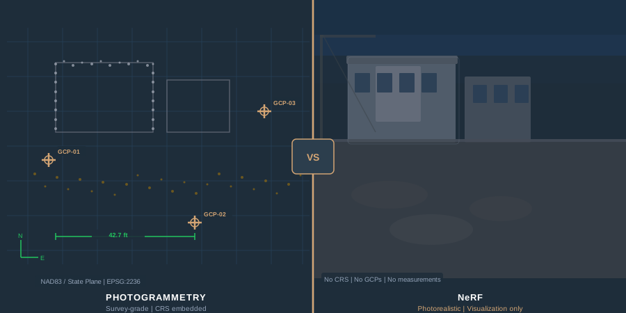
That’s the state of georeferenced NeRF vs photogrammetry in 2026. One produces stunning visuals. The other produces deliverables you can stake a property line from. They’re solving different problems, and the internet is terrible at explaining which one you actually need.
Survey-grade drone deliverables — orthomosaics, point clouds, DSMs — have a decade of field track record behind them with engineers, municipalities, and land developers. NeRF and Gaussian splatting, evaluated against those same survey workflows over the past eighteen months, occupy a very different slot. Here’s what the research and operator reports actually show, with real numbers instead of hype.
What NeRF Actually Is — And What It Isn’t
Neural Radiance Fields — NeRF — represent a scene as a continuous volumetric function. Feed it a 3D coordinate and a viewing direction, it returns a color and density. Train the network on a set of posed photographs, and it learns to synthesize new views from any angle. The result looks photorealistic because the model encodes lighting, reflections, and transparency implicitly.
The original NeRF paper (Mildenhall et al., ECCV 2020, with a follow-up survey article by the same authors in Communications of the ACM, January 2022) demonstrated that a multi-layer perceptron could produce novel views superior to anything traditional multi-view stereo achieved. That paper launched an avalanche: Instant NGP from NVIDIA compressed training from hours to minutes. Nerfstudio made the pipeline accessible. Luma AI put it on a phone.
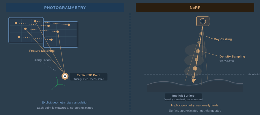
Here’s what NeRF does not do: triangulate geometry. Photogrammetry identifies corresponding feature points across overlapping images, triangulates their 3D positions using calibrated camera geometry, and builds a point cloud from explicit measurements. Every point has a provenance — you can trace it back to the images and the math that produced it. NeRF approximates geometry by sampling density along rays. The “surface” is wherever density crosses a threshold. There’s no triangulation, no explicit correspondence, and no measurement chain.
That distinction matters when someone hands you a spec that says “deliverables shall be accurate to 2 cm horizontal, 5 cm vertical, referenced to NAD83(2011) / State Plane.”
Accuracy: The Numbers Nobody Wants to Publish
Let’s get specific, because this is where the conversation usually gets vague.
Photogrammetry Accuracy
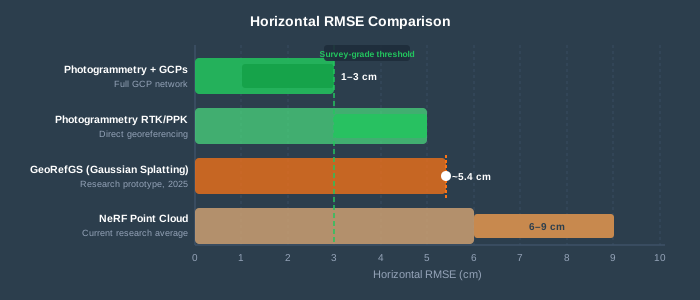
Photogrammetry with properly distributed GCPs delivers 1–3 cm horizontal RMSE and 2–5 cm vertical RMSE on standard drone survey flights (80% frontal overlap, 70% side overlap, 60–120 m AGL). Those numbers come from a decade of peer-reviewed validation and are reproducible across the major photogrammetry software platforms — Metashape, Pix4D, and OpenDroneMap when you follow the fundamentals. RTK/PPK direct georeferencing without GCPs lands around 3–5 cm horizontal, 5–10 cm vertical — still centimeter-class.
Every point in a photogrammetric point cloud has a computable error estimate. You run checkpoints, compare coordinates, calculate RMSE against ASPRS accuracy standards, and report it. The error chain is traceable from satellite constellation to base station to image geotag to bundle adjustment to final deliverable. Clients, engineers, and courts understand this chain.
NeRF Accuracy
NeRF accuracy data is thinner and less encouraging for survey applications.
A 2025 comparative study of Nerfstudio against Metashape (Tsukamoto et al., SICE Journal of Control, Measurement, and System Integration) found that the NeRF point cloud “contains substantial noise and shows a wavy surface even on a flat surface,” and concluded it is not appropriate as a highly accurate 3D model of an object’s size and shape.
Archaeological artifact reconstruction (MDPI Remote Sensing, 2025) showed NeRF outperformed Gaussian splatting on geometric fidelity but both techniques “still exhibit lower accuracy compared to SfM, particularly in preserving fine geometric details.”
Individual tree point clouds generated via NeRF (MDPI Remote Sensing, 2024) reconstructed more trees and filled canopies better, but tree height and diameter at breast height extracted from them were both less accurate than photogrammetric extraction. The NeRF clouds were noisy and low-resolution.
The Ortho-NeRF approach for generating true digital orthophotos from drone imagery has been reported, in published experiments, at roughly a 0.27 m average positional error tier — roughly 5 to 13 times the 2–5 cm that photogrammetric orthomosaics achieve on comparable projects with good GCPs. That ratio compares typical values across different projects; it is not a same-dataset comparison against Metashape or Pix4D.
GeoRefGS — a georeferenced Gaussian splatting framework published in Drones in 2026 (Hou et al.) — integrates CRS constraints directly into training and reports distance errors below 0.054 m (5.4 cm), measured as the mean distance to checkpoints in a simulated urban scene built in Unity. The paper is not consistent about that figure: its accuracy section (3.3) reports a mean planar error of 0.015 m and a mean vertical error of 0.053 m, with most reconstructed camera positions within 0.010 m of the true flight trajectory, while its ablation table lists a 0.054 m planar error for the full method. That’s among the more promising results published on the neural rendering side. But it’s a research prototype, not a production tool, and a 5.4 cm mean distance error on simulated data is not the same as validated checkpoint RMSE against independent survey control in the field.
The Accuracy Table
| Metric | Photogrammetry (GCPs) | Photogrammetry (RTK/PPK only) | NeRF (current research) | GeoRefGS (research prototype) |
|---|---|---|---|---|
| Horizontal RMSE | 1–3 cm | 3–5 cm | Lower accuracy than SfM; no consistent figure published | ~5.4 cm mean checkpoint distance error (simulated data) |
| Vertical RMSE | 2–5 cm | 5–10 cm | Not consistently reported | Not independently validated |
| Orthomosaic positional error | 2–5 cm | 5–10 cm | ~26.7 cm (Ortho-NeRF) | N/A |
| Error traceability | Full chain (GNSS → BA → checkpoint) | Full chain | None — no measurement chain | Partial (similarity transform) |
| Independent validation standard | ASPRS Positional Accuracy | ASPRS Positional Accuracy | No established standard | No established standard |
To put it plainly: photogrammetry measures geometry. NeRF approximates it. The gap is narrowing, but it’s still roughly 5–13x for orthomosaic work (comparing typical values across projects), and published point cloud comparisons consistently favor photogrammetry.
Output Products: What Each Method Actually Delivers
This is where the practical divide gets stark.
Photogrammetry Deliverables
Photogrammetry produces a defined set of survey products, each with established accuracy standards:
- Dense point cloud. Millions to billions of explicit 3D points with RGB color, each triangulated from image correspondences. Exportable as LAS/LAZ with classification. Directly usable in CAD, GIS, and civil engineering software.
- Orthomosaic. Orthorectified, seamless image map with defined ground sample distance and positional accuracy. GeoTIFF with embedded CRS. The bread and butter of drone survey deliverables.
- DSM/DTM. Digital surface and terrain models derived from the point cloud. Elevation grids with known vertical accuracy. Used for volume calculations, grading plans, flood modeling.
- Textured mesh. 3D surface model with photo texture. Used for visualization but also for volumetric measurement and BIM integration.
- Contour lines. Derived from DTM. Standard engineering deliverable.
Every one of these products carries a coordinate reference system. Every one can be validated against independent checkpoints. Every one plugs into the GIS and civil engineering software stack without conversion gymnastics.
NeRF Deliverables
NeRF’s native output is novel view synthesis — rendering the scene from new camera positions. Everything else requires extraction:
- Point cloud. Extracted by sampling the density field. Noisy, no established density standard, no per-point error estimate. Requires heavy post-processing (statistical outlier removal, surface reconstruction) before it’s usable. Not in a defined CRS unless you build a custom georeferencing pipeline.
- Mesh. Frameworks like NeRF2Mesh generate textured surface meshes through iterative refinement. Visual quality can be excellent. Geometric accuracy is not validated against survey standards.
- Orthomosaic. Research-only. Ortho-NeRF and NeRFOrtho demonstrate the concept but positional accuracy (0.267 m) doesn’t meet any survey specification I’ve encountered in practice.
- DSM/DTM. Not a standard NeRF output. Could theoretically be derived from an extracted point cloud, but the noise floor makes this impractical for engineering use.
- Novel views / fly-throughs. This is where NeRF dominates. Photorealistic rendering from any angle, including views never captured by the drone. No stitching artifacts, no projection distortions. Stunning for communication and visualization.
Product Comparison Table
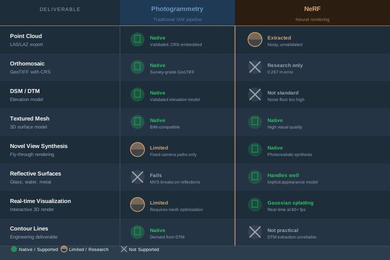
| Deliverable | Photogrammetry | NeRF | Winner |
|---|---|---|---|
| Survey-grade point cloud | Native, validated | Extracted, noisy, unvalidated | Photogrammetry |
| Orthomosaic (GeoTIFF) | Native, CRS-embedded | Research-only, 0.267 m error | Photogrammetry |
| DSM / DTM | Native, validated | Not standard output | Photogrammetry |
| Textured mesh | Native | Extracted (e.g. NeRF2Mesh); high visual quality, not validated | Photogrammetry for measurement; NeRF for visuals |
| Novel view synthesis | Limited (fixed camera paths) | Native, photorealistic | NeRF |
| Transparent/reflective surfaces | Fails or requires workarounds | Handles implicitly | NeRF |
| Real-time visualization | Requires mesh optimization | Gaussian splatting renders real-time | NeRF / 3DGS |
| Contour lines | Derived from DTM | Not practical | Photogrammetry |
CRS Integration: The Georeferencing Problem
Here’s where practitioners hit the wall with NeRF.
Photogrammetry has a mature, standardized georeferencing pipeline. Your drone captures images with GNSS-derived geotags. You (optionally) survey GCPs with a total station or RTK rover. You import images and GCP coordinates into Metashape, Pix4D, or ODM. The software runs bundle adjustment, refines camera positions, and produces deliverables in your specified CRS — NAD83, WGS84, EPSG:2236, whatever the project requires. The CRS is embedded in every output file. Done.
NeRF has no equivalent pipeline. Here’s what the georeferencing workflow looks like today:
-
COLMAP reconstructs camera poses. This is the standard SfM front-end for Nerfstudio and most NeRF pipelines. COLMAP estimates camera positions in an arbitrary local coordinate system — no CRS, no scale, no orientation to north.
-
COLMAP’s model_aligner transforms coordinates. If your images have GNSS geotags, you can use model_aligner to compute a similarity transform (rotation + scale + translation) from the local coordinate system to ECEF or ENU coordinates. This is a least-squares fit, not a rigorous bundle adjustment with GCP constraints.
-
The NeRF trains in transformed space. Nerfstudio can ingest the aligned COLMAP output, but the NeRF itself has no concept of a coordinate reference system. It’s just numbers in a transformed space.
-
You extract products and hope the transform held. Any point cloud or mesh you export carries the accuracy of that initial similarity transform — which depends entirely on your GNSS geotag quality and COLMAP’s pose estimation.
No commercial NeRF tool offers push-button CRS assignment. No NeRF pipeline supports GCP-constrained bundle adjustment the way Metashape or Pix4D does. No NeRF output embeds EPSG codes or projection metadata in the file headers.
GeoRefGS is the first serious attempt to fix this — it integrates a geographic loss function during Gaussian splatting training, simultaneously optimizing rendering quality and positional accuracy. The results are encouraging (mean checkpoint distance errors below 5.4 cm, on simulated data). But it’s a 2026 research paper, not shipping software.
For anyone delivering to a client, engineer, or municipal agency: your deliverables need a CRS. Photogrammetry gives you that natively. NeRF requires a custom pipeline and produces unvalidated results.
The Practitioner Decision Framework
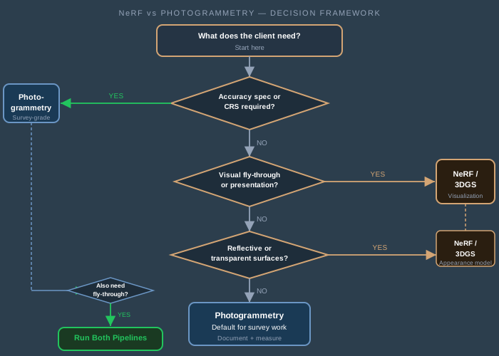
Stop thinking about NeRF vs photogrammetry drone mapping as a technology competition. Think about it as a deliverable question.
Use photogrammetry when:
- The deliverable has an accuracy specification. Any project with “accurate to X cm” in the scope requires photogrammetry. Full stop.
- The client needs a GeoTIFF orthomosaic. That’s 80% of drone survey contracts. NeRF can’t produce this at survey quality.
- You need to validate accuracy with checkpoints. Photogrammetry has a standard error reporting chain. NeRF has none.
- The product enters a GIS or CAD workflow. Photogrammetric products carry CRS metadata natively. NeRF exports require manual georeferencing.
- Volume calculations, grading, or engineering design depend on the data. The noise floor on NeRF point clouds makes volumetric accuracy unreliable.
- Legal or regulatory standards apply. ASPRS Positional Accuracy Standards, FEMA floodplain mapping, state DOT specifications — all written around photogrammetric deliverables.
Use NeRF or Gaussian splatting when:
- The deliverable is visual, not metrological. Marketing fly-throughs, stakeholder presentations, virtual site tours, heritage visualization — NeRF produces dramatically better visual output than photogrammetric mesh rendering.
- The scene contains reflective or transparent surfaces. Glass facades, water features, metallic structures — these break traditional multi-view stereo. NeRF handles them because it models appearance, not geometry.
- You need rapid visual documentation. Instant NGP can produce a navigable 3D scene from 200 photos in under 30 minutes. Photogrammetric processing of the same dataset takes hours.
- Supplemental visualization alongside photogrammetric deliverables. Run both pipelines on the same image set — photogrammetry for the survey products, NeRF for the client presentation. The images are already captured.
- Research or experimental work. If you’re pushing boundaries on ortho-generation or point cloud extraction, NeRF and 3DGS are where the research energy is. Just don’t promise survey-grade results to clients.
The DJI Terra 5.0 Signal
DJI added Gaussian splatting to Terra 5.0 in July 2025. That’s significant — the largest drone mapping software vendor signaling that neural rendering has a place in the workflow. But look at how they implemented it: Gaussian splatting handles the visualization layer. Traditional photogrammetry still generates the survey-grade orthomosaics, point clouds, and DSMs. DJI didn’t replace the measurement pipeline. They added a rendering pipeline alongside it.
That tells you where the industry is heading. Not replacement. Augmentation.
The Tools Right Now
If you’re evaluating NeRF tools for drone mapping workflows, here’s what exists today:
Nerfstudio — the most flexible open-source NeRF framework. Supports multiple NeRF architectures (Nerfacto, Instant NGP, TensoRF). Uses COLMAP for camera pose estimation. Exports point clouds and meshes. No georeferencing support. Requires a CUDA-capable GPU with 8+ GB VRAM. Free.
NVIDIA Instant NGP — extremely fast training (minutes, not hours). Lower visual quality than Nerfstudio’s best models but dramatically faster iteration. No georeferencing. Requires NVIDIA GPU. Free.
Luma AI — cloud-based, phone-friendly capture and NeRF reconstruction. Produces shareable 3D scenes. No georeferencing, no CRS, no export to survey formats. Consumer-oriented. Free tier available.
3D Gaussian Splatting (original implementation) — real-time rendering, faster training than NeRF, competitive visual quality. Active research community. No georeferencing in base implementation. Requires CUDA GPU. Free.
DJI Terra 5.0 — Gaussian splatting integrated alongside traditional photogrammetry. Survey-grade outputs still come from photogrammetric pipeline. Gaussian splatting adds visualization layer. Commercial license ($2,699–$4,999 depending on tier).
Metashape, Pix4D, OpenDroneMap — established photogrammetric tools. Full CRS support, GCP integration, checkpoint validation, all standard deliverables. What you’re already using. Nothing has changed here except these tools keep getting better at what they do.
The pattern is clear: NeRF tools are research-grade or visualization-grade. Photogrammetric tools are production-grade for survey deliverables. The convergence is happening — DJI Terra is proof — but it hasn’t happened yet.
Where This Is Going
I expect the accuracy gap to close. GeoRefGS demonstrated that geographic constraints can be embedded directly into neural rendering training. Ortho-NeRF and NeRFOrtho proved that orthomosaic generation from neural fields is possible, even if accuracy doesn’t meet survey specs today. The research trajectory is steep.
What won’t change is the need for traceable accuracy. Survey work is about producing a model that a professional engineer can sign, a court can accept, and an insurance company can underwrite — not a pretty picture. That requires a measurement chain: satellite signal to base station to image geotag to bundle adjustment to checkpoint validation. Photogrammetry has this chain. NeRF doesn’t — yet.
My prediction: within three to five years, commercial drone mapping software will use neural rendering internally for view synthesis, gap filling, and visualization — while photogrammetric triangulation continues to produce the measured geometry. You won’t choose between them. You’ll use both in the same pipeline, and the software will handle the handoff.
Until then, the decision framework is straightforward. Measure with photogrammetry. Visualize with NeRF. Don’t confuse the two.
Georeferenced NeRF is real — but georeferenced NeRF accuracy isn’t production-ready for survey work. Published point cloud comparisons consistently favor photogrammetry, and the orthomosaic gap is roughly 5–13x. No commercial NeRF tool supports CRS natively. No established validation standard exists for NeRF-derived survey products.
Photogrammetry remains the standard for any deliverable that requires a coordinate system, an accuracy specification, or legal defensibility. That covers the vast majority of professional drone survey work.
NeRF and Gaussian splatting produce dramatically better visual output. Use them for that. Run both pipelines on the same imagery when the project calls for both survey products and visual communication. The images are already captured — the marginal cost is processing time.
The technology is converging. DJI Terra 5.0 is the first commercial signal. But convergence isn’t here yet, and promising survey-grade results from a NeRF pipeline today would be irresponsible.
Know what each tool does. Use each for what it’s good at. That’s the practitioner answer.
For more on photogrammetric accuracy fundamentals, see ground control points for drone surveys. For positioning method selection, see RTK vs PPK drone mapping.
References
Research and standards cited in this article.
- ASPRS. (2024). ASPRS positional accuracy standards for digital geospatial data (Edition 2, Version 2.0). American Society for Photogrammetry and Remote Sensing. doi:10.14358/ASPRS.PAS.2024
- Chen, S., et al. (2025). Ortho-NeRF: Generating a true digital orthophoto map using the neural radiance field from unmanned aerial vehicle images. Geo-spatial Information Science, 28(2), 741–760. doi:10.1080/10095020.2023.2296014
- Hou, J., et al. (2026). GeoRefGS: Towards georeferenced 3D Gaussian splatting from unmanned aerial vehicle platforms. Drones, 10(3), 195. doi:10.3390/drones10030195
- Huang, H., Tian, G., & Chen, C. (2024). Evaluating the point cloud of individual trees generated from images based on neural radiance fields (NeRF) method. Remote Sensing, 16(6), 967. doi:10.3390/rs16060967
- Maté-González, M. Á., et al. (2025). Comparison of NeRF- and SfM-based methods for point cloud reconstruction for small-sized archaeological artifacts. Remote Sensing, 17(14), 2535. doi:10.3390/rs17142535
- Mildenhall, B., et al. (2020). NeRF: Representing scenes as neural radiance fields for view synthesis. Computer Vision – ECCV 2020, Lecture Notes in Computer Science 12346, 405–421. doi:10.1007/978-3-030-58452-8_24
- Mildenhall, B., et al. (2022). NeRF: Representing scenes as neural radiance fields for view synthesis. Communications of the ACM, 65(1), 99–106. doi:10.1145/3503250
- Tsukamoto, Y., et al. (2025). Comparative verification of 3D reconstructed point cloud data: Comparison of AI estimation and multi-view stereo methods using Nerfstudio and Metashape. SICE Journal of Control, Measurement, and System Integration, 18(1), 2497600. doi:10.1080/18824889.2025.2497600
- Yue, D., et al. (2025). NeRFOrtho: Orthographic projection images generation based on neural radiance fields. International Journal of Applied Earth Observation and Geoinformation, 136, 104378. doi:10.1016/j.jag.2025.104378