


You’re on a dealer’s product page. The cursor hovers over “Add to Cart” on a Matrice 350 Real-Time Kinematic (RTK) plus Zenmuse L2 plus D-RTK 3 setup. Close to forty thousand dollars once batteries and training are in. Your bookkeeper wants to know whether the next five years of jobs will absorb that number, or whether you should buy a Mavic 3 Enterprise RTK kit for roughly a fifth of the money and pocket the difference. Drone LiDAR cost is the question nobody answers honestly in one place.
A payback estimate that bills the LiDAR premium to every client looks short. The forums say it depends. Few people write down the actual math: hardware amortized across realistic job volume, plus the software, insurance, and skilled-labor lines that surface on the second invoice.
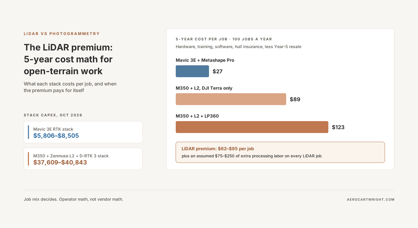
Here it is, with every assumption stated so you can swap in your own. At 100 jobs per year across five years, a Light Detection and Ranging (LiDAR) stack with LP360 works out to about $123 per job against $27 for a Mavic 3E running Agisoft Metashape Professional. That $95 gap (computed before rounding) is the floor. The processing-labor assumption in this model adds another $75–$250 on every LiDAR job. Volume alone barely rescues the purchase: the per-job gap stays above $30 until roughly 206 jobs a year (DJI Terra only) or 318 (with LP360). What pays for LiDAR is work photogrammetry can’t deliver.
This is the five-year amortization math for the When LiDAR Loses series. Operator math, not vendor math.
The Two Stacks, Honestly Priced
Price both rigs the same way: drone, RTK, base station, batteries, case, and LiDAR-specific training. All prices below are US dealer listings checked on 2026-10-02.
Availability first
All three headline products are at the end of their run. Global Drone HQ lists the Mavic 3 Enterprise as discontinued and names the Matrice 4E at $5,189 as its replacement (reseller). Its Zenmuse L2 page says the L2 “is no longer available” and points to the Zenmuse L3 at $17,400 on a Matrice 400 at $10,450 (reseller, prices it says were last verified August 2026). E38 Survey Solutions’ M350 combo page opens with “The M350 is no longer available” (reseller).
This article still models the M3E and M350 + L2 generation. That’s the gear operators already own, the gear still in some dealer stock, and the gear the used market trades. The cost structure carries over to the replacements; plug the newer prices into the same formula.
Mavic 3E RTK photogrammetry stack — $5,806–$8,505
E38’s Mavic 3 Enterprise RTK Kit for NTRIP bundles the drone, the RTK module and the three-battery kit for $5,227 (reseller; listed as unavailable on 2026-10-02). A GPC hard case is $579 (reseller). That’s $5,806, and it relies on a Network Transport of RTCM via Internet Protocol (NTRIP) correction service instead of your own base.
Add your own base and the stack becomes a survey rig that works where cellular coverage doesn’t. An Emlid Reach RS2+ is $2,699 (vendor). Emlid’s DJI RTK integration guide covers using the RS2/RS2+ as a base for DJI RTK drones including the Mavic 3E, either through Emlid Caster or through the Local NTRIP option “without connection to the internet” (vendor). Total: $5,227 + $579 + $2,699 = $8,505.
Matrice 350 + Zenmuse L2 + D-RTK 3 LiDAR stack — $37,609–$40,843
The Matrice 350 RTK Worry-Free Basic Combo lists at $14,814 at E38 (reseller), with two TB65 batteries, a BS65 battery station, a carrying case, the RC Plus controller and Enterprise Care Basic in the box. Global Drone HQ lists the M350 RTK at the same $14,814 and still orderable (reseller), even though E38 describes the M350 as no longer available.
The Zenmuse L2 runs $14,500 at Global Drone HQ (no longer available there) to $15,490 with Care Enterprise Plus at E38 (resellers). The D-RTK 3 Multifunctional Station is $2,199 base only or $2,839 with survey pole and tripod at DSLRPros (reseller).
The M350 flies on a pair of TB65 batteries (DJI specs — vendor), and E38’s own L2 starter bundle ships six. This model adds four TB65s to the combo’s two: 4 × $899 (DSLRPros) = $3,596, up to 4 × $1,075 (E38) = $4,300.
LiDAR training is the last one-time line. Blue Skies Drone Shop lists a one-day LiDAR mapping course at $2,500 and YellowScan LiDAR processing training at $3,400 (dealer). Pilot Institute’s self-paced Drone LiDAR Made Easy is $149 if you only need the basics. Part 107 applies to both stacks, so it’s left out of both.
What “all-in” actually includes
| Component | Mavic 3E RTK stack | M350 + L2 + D-RTK 3 stack |
|---|---|---|
| Drone, RTK, batteries (kit/combo) | $5,227 (M3E RTK kit: drone, RTK module, 3-battery kit) | $14,814 (M350 combo: 2× TB65, BS65, case, Care Basic) |
| Payload | (integrated camera) | $14,500–$15,490 (Zenmuse L2) |
| Base station | $0 (NTRIP) – $2,699 (Emlid RS2+) | $2,199–$2,839 (D-RTK 3) |
| Extra batteries | (in kit) | $3,596–$4,300 (4× TB65) |
| Case | $579 (GPC) | (in combo) |
| LiDAR training (one-time) | — | $2,500–$3,400 |
| All-in capex | $5,806–$8,505 | $37,609–$40,843 |
Low LiDAR sum: $14,814 + $14,500 + $2,199 + $3,596 + $2,500 = $37,609. High: $14,814 + $15,490 + $2,839 + $4,300 + $3,400 = $40,843. As a cross-check, E38’s L2 starter bundle with M350, six TB65s, an Emlid base and rover and a Virtual Surveyor subscription lists at $44,335.
The amortization model below uses the top of each range — $8,505 against $40,843, both stacks with their own base station. That’s a 4.8× capex gap ($40,843 ÷ $8,505).
Tariffs
These are listings checked a month after the Section 232 drone tariffs took effect on 2026-09-03. U.S. Customs and Border Protection’s CSMS #69738151 confirms the 10%–100% duties started that day, with a further 25% on other UAS components from 2027-02-09. Non-thermal unmanned aircraft of 25 kg or less carry the 25% rate; the M350’s maximum takeoff weight is 9.2 kg (DJI specs). Whether a LiDAR payload or a GNSS base imported on its own counts as a UAS component has not been established. The dealer listings don’t say whether they already pass the duty through. The Section 232 drone tariffs breakdown covers what’s taxed for mapping gear. Expect replacement and spare-part prices to move. Separately, since October 13, 2026 the FCC’s parts rule (FCC 26-50, new 47 CFR 2.903(b)(2)) bars new equipment authorizations for devices that contain logic-bearing components, such as chipsets or controller boards, made by Covered List entities including DJI and Autel; it is prospective, so every model priced here keeps its existing authorization, and its reach is new third-party gear built with DJI- or Autel-made parts (see what the FCC’s Covered List actions mean for DJI LiDAR rigs).
The 5-Year Drone LiDAR Cost Amortization Table
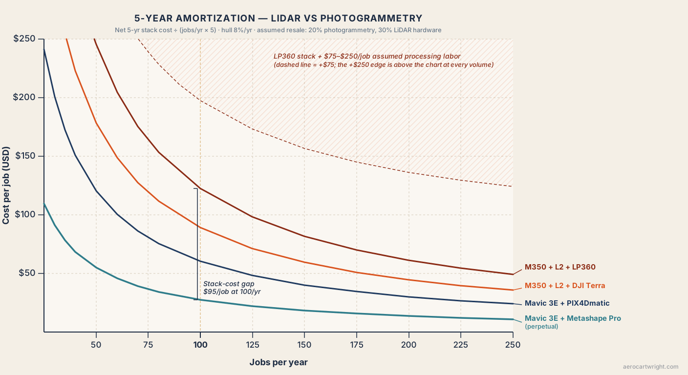
Four stack configurations, three annual job volumes, five years.
The formula: net five-year cost = hardware + training + software over five years + hull insurance over five years − Year-5 resale value of the hardware. Cost per job = net five-year cost ÷ (jobs per year × 5).
The assumptions, all of which you should replace with your own:
- Hardware: $8,505 photogrammetry; $37,443 LiDAR ($40,843 minus $3,400 training).
- Training: $3,400 one-time on the LiDAR side only.
- Software: Metashape Professional $3,499 one-time; PIX4Dmatic Standard $3,990/yr; DJI Terra LiDAR processing $0 (license included with the L2); LP360 Drone plus Strip Align $3,350/yr. Sources in the software section below.
- Hull insurance: 8% of hardware value per year, inside SkyWatch’s published 5–12% range. That’s $680/yr photogrammetry ($8,505 × 0.08) and $2,995/yr LiDAR ($37,443 × 0.08).
- Resale at Year 5: 20% of photogrammetry hardware ($1,701) and 30% of LiDAR hardware ($11,233).
- Not modeled: liability insurance (assumed to cost the same for either stack), Care renewals, repairs, workstation, NTRIP subscriptions, field labor and travel.
| Stack | 5-yr net cost | $/job @ 50/yr | $/job @ 100/yr | $/job @ 200/yr |
|---|---|---|---|---|
| Mavic 3E + Metashape Pro (perpetual) | $13,703 | $55 | $27 | $14 |
| Mavic 3E + PIX4Dmatic Standard (subscription) | $30,154 | $121 | $60 | $30 |
| M350 + L2 + DJI Terra only | $44,585 | $178 | $89 | $45 |
| M350 + L2 + LP360 | $61,335 | $245 | $123 | $61 |
| LiDAR premium per job vs Metashape baseline | — | +$124 to +$191 | +$62 to +$95 | +$31 to +$48 |
| Plus assumed processing labor ($75–$250/job) | — | +$199 to +$441 | +$137 to +$345 | +$106 to +$298 |
How each row adds up:
- Metashape: $8,505 + $3,499 + (5 × $680) − $1,701 = $13,703.
- PIX4Dmatic: $8,505 + (5 × $3,990) + (5 × $680) − $1,701 = $30,154.
- Terra only: $40,843 + (5 × $2,995) − $11,233 = $44,585.
- LP360: $44,585 + (5 × $3,350) = $61,335.
Premiums are computed from the unrounded figures. Terra only: ($44,585 − $13,703) ÷ 250 = $123.5 at 50 jobs per year. LP360: ($61,335 − $13,703) ÷ 250 = $190.5. The same method gives $61.8 and $95.3 at 100 jobs per year, and $30.9 and $47.6 at 200.
One baseline runs through the rest of this article: Mavic 3E + Metashape Pro. It is the cheapest photogrammetry row, so every LiDAR premium quoted here is the larger, honest one.
The LiDAR premium is real, and it doesn’t disappear at high volume. At 200 jobs per year, roughly four missions a week across 50 weeks, the gap compresses to $31–$48 per job. That only holds if processing labor is free, which it never is. Load the labor assumption back in and the 200-job gap becomes $106–$298 per job. At 50 jobs per year it becomes $199–$441.
The resale assumption barely moves the conclusion. At zero resale on both stacks, the LP360 gap at 100 jobs per year rises from $95 to $114 per job ($61,335 + $11,233 − $13,703 − $1,701 = $57,164; ÷ 500 = $114.3).
On open terrain, a Mavic 3E RTK stack at 100 jobs per year works out to $27 per job using Agisoft Metashape Professional on a perpetual license. That’s the photogrammetry-side number every LiDAR ROI claim has to beat.
The Line Items Payback Estimates Skip
The table above already carries software, hull insurance and one-time training. Below, the hull line gets its own explanation, followed by three costs optimistic payback estimates leave out: processing labor, calibration overhead and the learning curve. Each one is real money.
Hull insurance — about $2,300 per year differential in this model
SkyWatch puts hull insurance for commercial drones at “typically 5% to 12% of the insured value per year” (vendor). At the 8% this model assumes, the $8,505 photogrammetry hardware costs $680 a year to insure. The $37,443 LiDAR hardware costs $2,995. The difference is $2,315 a year. Across SkyWatch’s range it runs from $1,447 (5%: $1,872 − $425) to $3,472 (12%: $4,493 − $1,021).
Liability is a different line. SkyWatch’s $1M liability annual plan starts at $750 (vendor). This model assumes the liability premium doesn’t depend on which drone you fly, so it leaves liability out of both stacks; check that against your own quote. The differential is hull-only, but it lasts as long as you own the equipment.
Skilled processing labor — the assumption that decides the answer
No industry survey publishes processing hours by method, so this is a stated assumption, not a measurement. Photogrammetry on an RTK job is mostly machine time plus a quality-control pass. LiDAR adds work that a senior operator does by hand: point classification, strip alignment, ground-filter tuning, and boresight checks.
This model assumes LiDAR adds 1.5 to 5 hours of senior-operator time per job. At $50 per hour fully loaded, that’s $75–$250 per job. Use your own hours and your own rate. The line grows with every job you fly, so there’s no economy of scale on it.
Calibration and checkpoint overhead
Drone LiDAR carries calibration steps photogrammetry doesn’t. Microdrones says boresight calibration matters “after payload integration and when starting new projects” (vendor). Routescene recommends “4-8 targets” for boresight calibration and checkpoints on a 500 × 500 m area (vendor). DJI’s L2 accuracy figures were measured on Pilot 2 area routes “with Calibrate IMU enabled” (reseller summary). None of this is priced in the table above. Count it as field time on every new site.
Training and the learning curve
Both methods require Part 107. LiDAR adds a course ($149–$3,400 in the listings above) and a learning curve before point-cloud classification is routine. That’s a delay-to-revenue cost as much as an invoice. Early LiDAR deliverables need senior review. The cost shows up in the calendar.
Software — The $0–$3,990-Per-Year Variable
Software is where an operator can drop $3,990 a year off the photogrammetry side, or add $3,000-plus a year to the LiDAR side. On the photogrammetry side, five years of PIX4Dmatic Standard ($19,950) costs more than the hardware it runs on ($8,505).
Photogrammetry side
Pix4Dmapper is $3,990 per year on subscription, $332.50 per month billed yearly (vendor). PIX4Dmatic runs $2,290 per year (Analyst), $3,990 (Standard) or $4,990 (Pro), with no perpetual option on the pricing page (vendor). Agisoft Metashape Professional is $3,499 for a perpetual node-locked license (vendor). RealityScan is free for individuals and businesses under $1 million in revenue over the past 12 months and $1,250 per seat per year above it (vendor).
LiDAR side
DJI Terra is the floor for L2 operators. E38’s L2 listing says the payload “includes a permanent license of DJI Terra LiDAR Point Cloud Processing, as well as a 3 month license of DJI terra Full-Featured” (reseller). That’s why the Terra-only row carries $0 software. DJI’s Terra V5.1 announcement of free LiDAR reconstruction covers the newer Zenmuse L3 (vendor).
LP360 Drone is one upgrade path for heavier LiDAR classification and strip alignment. Maverick Drone lists the 12-month LP360 Drone subscription at $1,675 and the 12-month Strip Align add-on at $1,675, or $5,585 for a perpetual LP360 Drone license (reseller). Blue Skies Drone Shop lists the 12-month subscription at $1,575 (dealer). The model uses $1,675 + $1,675 = $3,350 per year. Terrasolid’s suite is a further step up for multi-pilot survey firms; it isn’t modeled here.
The Metashape perpetual move — quietly the cheapest legitimate pipeline
Look at the amortization table again. Mavic 3E + Metashape Pro lands at $13,703 net over five years. Mavic 3E + PIX4Dmatic Standard lands at $30,154. Same hardware. The $16,451 gap is one software-license decision: five years of $3,990 is $19,950, minus Metashape’s one-time $3,499.
Metashape on perpetual isn’t a hack. For an operator flying open terrain, it’s the cheapest paid photogrammetry pipeline in this comparison, and its listed price is one-time rather than annual.
Depreciation and Resale Reality
Every five-year amortization model has to take a position on resale value at Year 5. Honest answer: nobody publishes the number.
No industry survey of enterprise drone or LiDAR payload resale values turned up for this article. The residual values in this model are assumptions: 20% on the Mavic 3E hardware and 30% on the M350 + L2 hardware. The idea is that a payload holds value somewhat better than an airframe. Your local used market may disagree.
Discontinuation adds a second risk. With the L2, M350 and M3E all listed as no longer available at major US dealers, Year-5 buyers will be comparing them against the Zenmuse L3, Matrice 400 and Matrice 4E. Operators flying a “use it until it dies” model should run the math with zero residual on both sides. As shown above, that moves the 100-jobs LP360 gap from $95 to $114 per job. It doesn’t change the verdict.
Two Operator Profiles — The Same Math, Different Mix
The amortization table is the same for every reader. The conclusion isn’t, because the job mix isn’t. Two hypothetical profiles show how the same numbers produce opposite verdicts.
Case A — Quarry surveyor, 80 jobs per year, no canopy
The operator flies exposed-aggregate stockpiles, pit-wall progress, and reclamation volumetrics. Zero canopy. Deliverable: a Digital Elevation Model (DEM), an orthomosaic, and a volume report. Photogrammetry produces all three natively.
The Mavic 3E + Metashape Pro stack works out to $34 per job at 80 jobs per year ($13,703 ÷ 400 jobs = $34.26). The M350 + L2 + LP360 stack works out to $153 per job at the same volume ($61,335 ÷ 400 = $153.34). Per-job premium: $119. Add the assumed $75–$250 in extra processing labor and the gap is $194–$369 per job. Doming? As the doming workflow article shows, that’s a flight-plan decision, not a hardware purchase.
None of those 80 jobs needs anything photogrammetry can’t deliver, so there’s no revenue on the other side of the ledger to cover the premium. Verdict: stay on photogrammetry.
Case B — Utility-corridor mapper, 60 jobs per year, mostly vegetated
The operator flies transmission rights-of-way and pipeline corridors through mixed vegetation. Suppose 39 of the 60 jobs (65%) require a bare-earth Digital Terrain Model (DTM) under leaf-on or evergreen canopy, plus wire-versus-vegetation separation. Those are deliverables photogrammetry can’t reliably produce. The other 21 jobs are open ground.
On the Metashape baseline the photogrammetry stack costs $46 per job ($13,703 ÷ 300 = $45.68), but it can’t deliver the 39 canopy jobs. The operator declines them or subcontracts them. The LiDAR stack costs $204 per job ($61,335 ÷ 300 = $204.45). Add the model’s processing-labor assumption of 1.5 to 5 extra senior hours per LiDAR job at $50 an hour ($75–$250), and each LiDAR job costs $279–$454 ($204.45 + $75 = $279.45; $204.45 + $250 = $454.45) before baseline quality control, field time and travel.
The question is whether the 39 jobs photogrammetry can’t deliver cover the extra $9,526 a year the LiDAR stack costs ($47,632 over five years ÷ 5). They do if each one leaves at least $245 of margin after its own labor and field costs ($9,526 ÷ 39 = $244.26). Your corridor rates decide that, not this article. If your quotes clear that bar comfortably, LiDAR is the price of admission to canopy work and the market pays it.
Same hardware. Same numbers. Opposite verdicts. Job mix decides every operator’s answer.
The Break-Even Questions (Honest, Not Vendor Math)
Three questions resolve the purchase decision without leaning on vendor ROI calculators.
How much of your book does only LiDAR deliver?
Forget canopy-cover percentages as a buying rule. The 40%, 60% or 70% canopy figures that circulate are rules of thumb, not published limits. Wallace et al. (2016) in Forests describe a gradient, not a cutoff: on a eucalypt forest plot, Structure from Motion (SfM) photogrammetry “underperformed ALS in capturing the terrain surface under increasingly denser canopy cover”, where ALS is drone-mounted airborne laser scanning. The 50% and 63% figures in that paper are two canopy-cover estimates of the same plot, not thresholds.
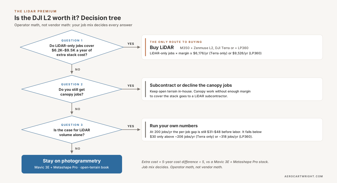
The decision variable is the number of jobs per year that need a deliverable photogrammetry can’t produce: ground under leaf-on or evergreen canopy, conductor clearance, and similar work. The formula: LiDAR pays when (jobs only LiDAR can deliver × margin per such job) ≥ the stack’s extra annual cost. In this model that extra cost is $9,526 a year with LP360, or $6,176 with DJI Terra only ($30,882 ÷ 5).
As a hypothetical, at $500 of margin per canopy job after labor, you need 20 such jobs a year with LP360 ($9,526 ÷ 500 = 19.05) or 13 with Terra only ($6,176 ÷ 500 = 12.35). Below that, photogrammetry handles the open-terrain majority and you decline or subcontract the canopy work.
What job volume compresses the differential?
Not as much as you’d hope. The per-job premium over the Metashape stack drops below $30 only above about 206 jobs per year on Terra only ($6,176 ÷ $30 = 205.9) and about 318 with LP360 ($9,526 ÷ $30 = 317.5). At 200 jobs per year it’s still $31–$48, before labor. 200 jobs a year is roughly four missions a week across 50 working weeks, a fleet pace for most one-pilot businesses. An operation at that volume can justify running both stacks and deploying the right tool per job rather than forcing one rig across all work.
When LiDAR pays off (and when it never does)
LiDAR pays off when the book holds a steady stream of canopy or corridor work photogrammetry can’t service, at margins that cover the stack’s extra annual cost. It never pays off on a pure open-terrain stockpile, construction, or solar book. The client has no reason to pay a premium for a deliverable photogrammetry already produces, and the photogrammetry-flying competitor sets the market price.
A payback estimate that bills the LiDAR premium back to every client is vendor math. In this article’s view, clients pay LiDAR pricing when they need a LiDAR deliverable. On everything else they expect photogrammetry pricing, or they take the work to a competitor who charges it.
Where This Article Hands Off
The When LiDAR Loses series covers the rest of the argument: photogrammetry’s vertical accuracy on open terrain, the orthomosaic a LiDAR-only flight leaves behind, stockpile volumes, canopy and leaf-state limits, and vertical structures. The capex math in this piece only matters because photogrammetry’s accuracy on open terrain is competitive.
The standard objection to photogrammetric accuracy is doming. The doming workflow article walks through James & Robson 2014’s oblique-imagery fix, which cut DEM error by up to two orders of magnitude in simulations without ground control, and needs no new hardware.
The series ties back to the LiDAR vs Photogrammetry comparison pillar.
Bottom Line — Is the DJI L2 Worth It?
An M350 + Zenmuse L2 + D-RTK 3 stack is a $37,609–$40,843 capex decision at October 2026 dealer prices, against $5,806–$8,505 for a Mavic 3E RTK stack. At 100 jobs per year over five years it works out to $123 per job with LP360 versus $27 for a Mavic 3E + Metashape Pro perpetual stack, about 4.5 times the cost per job ($122.67 ÷ $27.41). The assumed processing labor adds $75–$250 more on every LiDAR job. That’s the LiDAR vs photogrammetry cost reality.
The L2 is the right purchase for forestry, powerline-corridor, and bare-earth-under-vegetation work. It earns its keep when those jobs arrive steadily enough, at good enough margins, to cover roughly $6,200–$9,500 of extra cost a year. For everything else — stockpiles, construction, solar farms, open-terrain surveys — the LiDAR premium buys accuracy nobody is billing for, and the photogrammetry-flying competitor wins the bid.
Operator math, not vendor math. The formula doesn’t change. Your job mix, your rates and your labor hours decide which side of it you live on.
References
Research and standards cited in this article.
- James, M. R., & Robson, S. (2014). Mitigating systematic error in topographic models derived from UAV and ground-based image networks. Earth Surface Processes and Landforms, 39(10), 1413–1420. doi:10.1002/esp.3609
- Wallace, L., et al. (2016). Assessment of forest structure using two UAV techniques: A comparison of airborne laser scanning and structure from motion (SfM) point clouds. Forests, 7(3), 62. doi:10.3390/f7030062