



Updated October 2026: We corrected which airspace needs an FAA authorization (Class B, C, D and Class E surface areas only, not all controlled airspace), replaced a 72-hour LAANC further-coordination rule that the FAA does not have with its actual 90-day window, updated the LAANC supplier count, DroneZone processing time and Part 107 waiver portal, and swapped an unverified fine range for figures from the FAA’s own enforcement summary. A later pass clarified that Part 107 covers any non-recreational flight, paid or not, corrected the civil penalty caps for individuals and small businesses (the $75,000 cap applies to larger companies), and tightened the SkyPan, Remote ID and 400-foot details.
You’re standing on a job site, drone on the pad, ready to fly a commercial survey. A manned aircraft enters the area at 500 feet AGL. You didn’t check the sectional chart. You don’t have ADS-B monitoring running. You have no idea whether you’re operating in controlled airspace or under a VFR corridor.
That’s not a hypothetical. That’s a Tuesday for operators who treat their Part 107 certificate like a box they checked once and forgot about.
Here’s the thing most drone operators miss: when you passed your Part 107 exam and the FAA issued your Remote Pilot Certificate, they entered you into the same pilot database as the captain flying a 737 out of DFW. Not a separate hobbyist registry. Not a drone-only list. The same integrated airman certification database that tracks every certificated pilot in the United States.
Under federal law, you are a government-regulated pilot. The expectations are real — and the consequences for ignoring them are expensive.
Part 107 Is Not a Formality
If you fly a drone in the United States for any reason that isn’t strictly recreational under 49 U.S.C. 44809, Part 107 applies and the pilot in command needs an FAA Remote Pilot Certificate (14 CFR 107.1, 107.12). Paid or unpaid makes no difference. Narrow exceptions include public aircraft operations under an FAA certificate of authorization and operations under a 49 U.S.C. 44807 exemption.
The FAA’s own language: “In order to fly your drone under the FAA’s Small UAS Rule (Part 107), you must obtain a Remote Pilot Certificate from the FAA. This certificate demonstrates that you understand the regulations, operating requirements, and procedures for safely flying drones.”
To put it plainly: if the flight isn’t recreational, Part 107 is mandatory, whether or not money changes hands.
What most operators don’t realize is how close Part 107 sits to manned aviation certification. The knowledge test overlaps heavily with the Part 61 private pilot ground school curriculum — airspace classifications, weather theory, aeronautical decision-making, radio communications, sectional chart reading. The FAA treats these certifications as part of the same system because they are part of the same system. You share airspace with manned aircraft. The rules exist to keep everyone in that airspace alive.
Enforcement Is Real and the Fines Are Steep
Anyone who flies a drone is subject to FAA enforcement, certificated or not — the same agency that grounds airlines and pulls ATP certificates from 30-year captains. Every case named in the FAA’s 2024 summary below involved an operator with no Remote Pilot Certificate at all.
Rupprecht Law tracks FAA enforcement actions against drone operators, and the FAA publishes its own case summaries. The numbers:
- Recent examples: The FAA’s August 2024 enforcement summary listed proposed penalties from $4,000 to $32,700 for flying in controlled airspace without authorization, flying without a Remote Pilot Certificate, and ignoring temporary flight restrictions. The FAA says fines can now reach $75,000 per violation, but under 49 U.S.C. 46301 that cap applies to companies other than small businesses. The inflation-adjusted cap for an individual or small business is $17,062 per violation, and $1,875 for an individual serving as an airman (14 CFR 13.301).
- Upper range: Before Part 107 existed, the FAA proposed a $1.9 million penalty against SkyPan International for 65 unauthorized flights over New York City and Chicago between 2012 and 2014. The case settled for $200,000, and the FAA made no finding of violation. The numbers still climb fast, because federal law counts each flight involving a violation as a separate violation (49 U.S.C. 46301(a)(2)).
- Certificate action: The FAA can suspend or revoke your Part 107 certificate entirely. During a suspension or after revocation, you cannot legally fly under Part 107 at all. Revocation and suspension orders go through the FAA’s legal enforcement process — most can be appealed to the NTSB, but there is no shortcut back.
These aren’t theoretical threats. Treat your certificate as optional or your airspace obligations as suggestions and you’re stacking financial and legal risk you don’t need.
Know Your Airspace — This Is the Job
Pre-flight safety checks and operational limits matter — if you’re flying commercial drone mapping operations, a structured workflow from pre-flight through data delivery is what separates disciplined operators from the ones who cut corners. But the single highest-value skill you can develop as a Part 107 pilot is airspace awareness. You share the National Airspace System with manned aircraft. Know where you are in that system — and who else is operating around you — or you’re one radio call away from a near-miss report.
Two tools make this possible. Use both.
ADS-B Monitoring
ADS-B (Automatic Dependent Surveillance-Broadcast) is the system manned aircraft use to broadcast their position, altitude, speed, and identification in real time. Some drones — the DJI Matrice 350 RTK, for example — have ADS-B In receivers built into the airframe. If yours doesn’t, run a ground-based solution.
Options for ADS-B awareness:
- Built-in drone receiver. Check your platform specs. If your drone has ADS-B In, it alerts you to nearby aircraft during flight. Best option — zero additional setup.
- Portable ADS-B receiver. Devices like the uAvionix pingStation or Stratux feed traffic data to a tablet on the ground. Use this if your drone lacks onboard ADS-B.
- Web-based tracking. FlightRadar24 or FlightAware show near-real-time aircraft positions. Not as fast as a local receiver — delays range from a few seconds for ADS-B-equipped aircraft to several minutes for radar-only feeds — but far better than flying blind.
The goal is simple: know what’s flying near you before it becomes a conflict. ADS-B gives you that lead time.
FAA Sectional Charts
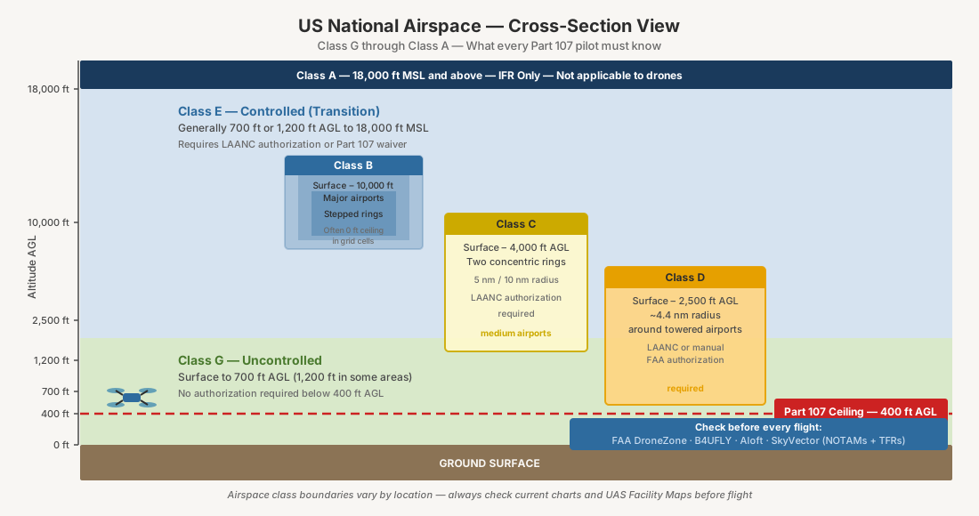
Sectional charts are the maps that define the National Airspace System. They show airspace classifications — Class B, C, D, E, G — along with altitude floors and ceilings, restricted and prohibited areas, military operating areas, radio frequencies, navigation aids, and obstacles.
Every Part 107 pilot studied sectional charts for the knowledge test. Most stopped looking at them the day after they passed.
That’s a mistake. Your drone’s built-in geofencing is not a substitute for reading the actual chart. Geofencing databases lag behind NOTAMs and TFRs. They don’t show you the full picture — temporary flight restrictions, active military airspace, the specific altitude boundaries that determine whether you need a LAANC authorization.
Before every commercial flight:
- Pull the current sectional for your operating area. Free at SkyVector or through ForeFlight.
- Identify the airspace class and its altitude boundaries. Class G surface airspace up to 400 feet AGL is the simplest case — no authorization required. The same goes for Class E airspace that starts at 700 or 1,200 feet AGL. Class B, C, and D airspace, and Class E surface areas around airports, demand an airspace authorization through LAANC or FAADroneZone before you fly (14 CFR 107.41). Flying above 400 feet is a separate limit that takes a Part 107 waiver, unless you stay within 400 feet of a structure and no more than 400 feet above its top (14 CFR 107.51(b)).
- Check NOTAMs and TFRs. Temporary flight restrictions override everything on the sectional. Presidential movements, wildfire operations, sporting events — these pop up with little notice and carry severe penalties for violation.
- Note the local radio frequencies. The bonus move that separates competent operators from sharp ones. If you have an aviation handheld radio or a scanner, monitor the CTAF or tower frequency listed on the chart. You’ll hear manned traffic announcing their position and intentions in your area — information ADS-B alone won’t give you, especially for aircraft without ADS-B Out. That includes a lot of general aviation aircraft flying under VFR.
Remote ID — Your Drone’s Digital License Plate
Every drone that requires FAA registration has had to broadcast Remote ID since September 16, 2023 (14 CFR 89.105). The FAA’s discretionary enforcement window closed on March 16, 2024. No grace period remains. Fly without Remote ID and you face fines, certificate suspension, or revocation.
Remote ID is exactly what it sounds like — a digital license plate. Under 14 CFR 89.305, your drone continuously broadcasts its identity (serial number or session ID), latitude and longitude, geometric altitude, velocity, control station location and altitude, a UTC time mark, and emergency status. Anyone with a Remote ID receiver or a smartphone app can see who’s flying, where they’re flying, and where the pilot is standing. That’s the point — accountability in the airspace.
Two ways to comply. Standard Remote ID ships built into the drone’s firmware — it broadcasts the full message set under 14 CFR 89.305, including your real-time control station position and emergency status. A broadcast module is the retrofit path for older aircraft — under 14 CFR 89.315, it transmits the drone’s takeoff location instead of a dynamic control station position and skips emergency status. Still counts, with one condition: when you fly with a broadcast module, you must be able to see the drone for the entire flight (14 CFR 89.115(a)).
Most current enterprise platforms already comply. The DJI Mavic 3 Enterprise series shipped with Remote ID built in. The M350 RTK has it native. The M300 RTK picked it up through a firmware update — version 05.01.01.00 and later. Running a Matrice 200 series, a Phantom 4 RTK, or anything older? You need a third-party broadcast module from Dronetag or uAvionix.
The main exception is a FRIA — an FAA-Recognized Identification Area. (The FAA can also authorize specific flights without Remote ID, such as aeronautical research under 14 CFR 89.120, but that is case by case.) These are specific geographic zones established by FAA-recognized community-based organizations and educational institutions. Drones without Remote ID can fly within them, but you and the drone must stay inside the FRIA boundary for the entire flight and you must maintain visual line of sight. For commercial operators on job sites, FRIAs are irrelevant. Your work goes where the project is — not where a flying club drew a line on a map.
Here’s why this matters beyond compliance. Remote ID separates professional operators from rogue flyers. When a client, a property owner, or law enforcement sees a drone overhead and checks the broadcast, your operation shows up as registered, identified, and accountable. The guy flying a $200 toy with no Remote ID and no Part 107 does not. That distinction is your credibility — and now anyone with a smartphone can see it.
LAANC — Automated Airspace Authorization
You will fly in controlled airspace. Every commercial operator does eventually. LAANC is the system that keeps you legal without losing a week to paperwork.
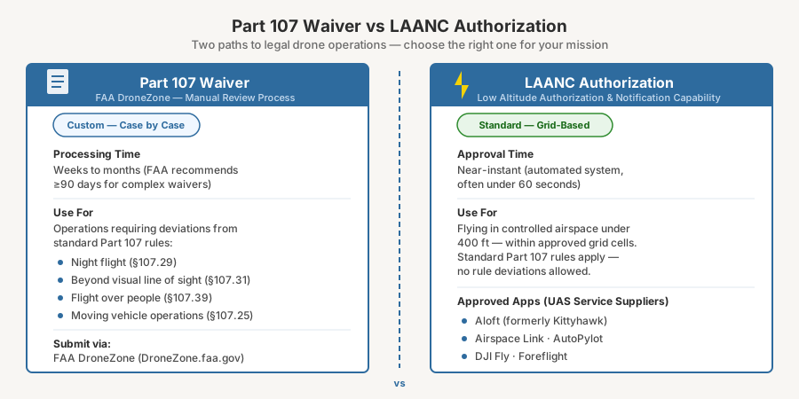
LAANC stands for Low Altitude Authorization and Notification Capability. Before LAANC, every controlled airspace authorization meant a manual request through the FAA’s DroneZone portal, which the FAA says has historically taken up to eight weeks to process. That manual process still exists for airports without LAANC coverage. But LAANC handles the bulk of controlled airspace authorizations in near-real time. Often in under a minute.
How it works. The FAA publishes UAS Facility Maps that divide controlled airspace around participating airports into a grid. Each cell covers 30 arcseconds of latitude by 30 arcseconds of longitude — roughly half a mile on a side in the continental U.S. Every cell has a pre-approved maximum altitude ceiling — sometimes 0 feet, sometimes 100, 200, or 400 feet AGL. Submit a request through an approved app, the system checks your proposed altitude against that ceiling, and if you’re at or below it, you get an instant authorization. No phone calls. No emails. No waiting.
Approved apps. The FAA maintains a list of approved UAS Service Suppliers — 12 of which currently offer public LAANC access through desktop and mobile apps. Aloft, Airspace Link, and AutoPylot are among them. Full list on the FAA LAANC page. Pick one that fits your workflow and stick with it.
When LAANC is not enough. If your operation requires flying above the pre-approved ceiling for a given cell — say the grid shows 100 feet but you need 300 — you submit a “further coordination” request through the same app. You can submit these up to 90 days before your planned flight (Part 107 pilots only), and they take longer because the FAA coordinates them manually. Operations that need waivers beyond standard Part 107 rules — flying over people without proper category compliance, beyond visual line of sight — still go through the Part 107 waiver process, which has moved from DroneZone to the FAA’s Aviation Safety Hub. The FAA aims to decide waiver requests within 90 days of submission. Plan accordingly.
Build LAANC into your pre-flight workflow. Pull the sectional chart first. Identify the airspace class. Check the UAS Facility Map for your grid cell’s altitude ceiling. Submit the LAANC request. Confirm the authorization before the drone leaves the ground. Five minutes. That’s it. And it eliminates the single most common source of airspace violations — flying in controlled airspace without authorization. Five minutes of process versus a five-figure fine. Do the math. If you don’t already have a structured drone pre-flight checklist, this is the right time to build one — LAANC authorization belongs on it alongside battery checks and compass calibration.
Your Part 107 certificate is a federal pilot certification. It puts you in the same regulatory system as every other pilot in U.S. airspace. The FAA enforces it accordingly — fines can reach $17,062 per violation for an individual or small business and $75,000 for a larger company, each flight can count as a separate violation, and certificate revocation is on the table for serious offenses.
The operators who treat this seriously — who check sectional charts, run ADS-B monitoring, and understand the airspace they’re flying in — are the ones building sustainable businesses. The ones who don’t are accumulating risk they can’t see until an enforcement letter shows up. A deeper look at how risk actually works in drone mapping — regulatory, collision, privacy, and GPS interference — is worth your time before your next commercial flight.
Part 107 exists to keep the National Airspace System safe. Operating under it with the discipline it demands doesn’t just make you compliant — it makes you a better pilot.