


Updated November 2, 2026: We added the Part 108 statutory deadline, the FCC’s October 29 order opening the 800 MHz Cellular band to drones, the FCC’s November 19 drone spectrum agenda, and the authorization path for BVLOS jobs before Part 108 takes effect. See the status box under “The Regulatory Status.”
Updated October 2026: We now point waiver applicants to the FAA Aviation Safety Hub (which has replaced DroneZone for Part 107 waiver applications), the FAA’s 90-day review goal, and its list of issued waivers; removed an incorrect form number, an unsourced waiver count, and unsourced claims about common denial reasons and Class G approvals; corrected platform details (Dragonfish range now limits single-flight runs to about 35 miles with the base station at the midpoint, payload 2.5 kg, 180 min as a dealer-listed maximum; Dock 2 charges in place and needs at least a half-hour between flights; Casia 360 is a detect-and-avoid sensor rather than an aircraft); replaced unverified PPK and insurance prices with qualitative guidance; fixed the PPK range and accuracy claims and the corridor crew math; and added a note on the FCC Covered List for DJI and Autel hardware, including when its Blue UAS and Buy American exemptions were added.
You’re mapping a 15-mile pipeline corridor. Under Part 107 VLOS rules, you’re staging crew positions roughly 2 miles apart, each covering about a mile in either direction, so the corridor takes about eight of them. Each position needs two pilots rotating through batteries: several days in the field and a logistics train that doubles your crew count just to keep things moving. The client wants RTK-grade orthomosaics. By day two, your crew is exhausted. Margins compress. Quality slips.
With BVLOS, that same corridor becomes one operator, one morning, one platform. A fixed-wing VTOL launches at dawn, flies the entire length, returns before lunch, lands itself in your truck bed. You downlink the imagery, process PPK positioning, and deliver the mosaic the next day. The technology exists now. The rules are still a proposal, and as proposed they would change how mapping shops scale.
This is not theoretical. The FAA has published its proposed rule. The executive order is signed. As of November 2, 2026, Part 108 is still a proposed rule: the FAA’s final-rule draft went to White House review in July 2026, and no final rule has been published. Operators who understand what’s coming—who’ve already built the safety case, trained their crews, and positioned their equipment—will move faster than the market.
Here’s what you need to know, what you need to do, and how the math actually works on real projects.
The Regulatory Status: Where Things Stand Right Now
Part 108 status, updated November 2, 2026. Part 108 is still a proposed rule. The FAA’s final-rule draft went to the White House Office of Information and Regulatory Affairs (OIRA) for review on July 10, 2026 (reginfo.gov, RIN 2120-AL82), and no final rule had been published in the Federal Register as of November 2, 2026. Two official targets have passed: the executive order’s 240-day deadline (February 1, 2026) and the Unified Agenda’s July 2026 target. There are no effective or compliance dates yet. Everything below about Part 108 describes the August 2025 proposal (90 FR 38212), and any of it can change in the final rule.
What’s changed since October 25:
- Statutory deadline: December 7, 2026. Federal law requires the FAA to issue the final rule within 16 months of publishing the proposed rule (49 U.S.C. 44811(c)). The proposal published August 7, 2025, so the deadline falls on December 7, 2026 (my calculation). A statutory deadline is a requirement on the agency, not a publication date, and reginfo.gov still showed the rule pending review on November 2.
- October 29, 2026: the FCC opened the 800 MHz Cellular band to drones. The Report and Order (FCC 26-72, released October 30) changes 47 CFR 22.925 so UAS can use the band for command, control, communication, and payload links. It takes effect 30 days after it publishes in the Federal Register, which hadn’t happened as of November 2. It’s spectrum access, not FAA authority: it doesn’t authorize a single BVLOS flight.
- November 19, 2026: more FCC drone spectrum items on the agenda. The FCC Chairman announced on October 28 that the Commission will vote on orders that would open the 450 MHz band to safety-related air-ground data links for crewed and uncrewed aircraft under nationwide licensing, and let ground-based radar use 24.45–24.65 GHz to detect and track drones (FCC news release, October 28, 2026). Nothing changes unless the Commission adopts them.
- For Q4 jobs, the path hasn’t changed. Until a final Part 108 rule publishes and reaches its effective date, BVLOS work needs a §107.31 waiver (14 CFR 107.205(c) lists 107.31 as waivable) or, for operations Part 107 doesn’t cover, an exemption under 49 U.S.C. 44807. The final rule will set its own effective and compliance dates, so don’t schedule a job on Part 108 until those dates are published.
BVLOS operations are not yet legal under the standard rules. Part 107.31 prohibits flights beyond visual line of sight, with narrow exceptions. For small-UAS mapping work, a Part 107 waiver is the practical route today.
The Current Waiver Regime
The FAA has issued §107.31 BVLOS waivers since Part 107 took effect in 2016, and it lists every issued waiver, with the sections each one waives, on its Part 107 Waivers Issued page. These waivers grant relief from Part 107.31 under specific conditions: defined corridors, crew composition, aircraft systems, and contingency procedures. Waiver holders include power utilities, agriculture operators, construction firms, and surveying companies.
A waiver costs time, not money. There is no filing fee, and Part 107 waiver applications now go through the FAA’s Aviation Safety Hub rather than DroneZone (airspace authorizations stay in DroneZone). The FAA says it will do its best to approve or disapprove waiver requests within 90 days of submission; complex or incomplete requests take longer. Operators who arrive with the foundation in place (a described detect-and-avoid method, crew training, contingency procedures) give the reviewer less to ask about.
The Proposed Rule: Part 108
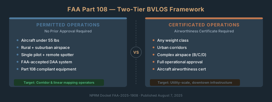
On August 7, 2025, the FAA published an NPRM (Notice of Proposed Rulemaking) under docket FAA-2025-1908, titled “Normalizing Unmanned Aircraft Systems Beyond Visual Line of Sight Operations” (90 FR 38212). The rule proposes a new Part 108 with two pathways:
Permits. The lighter pathway. The FAA would issue permits by operation type, and aerial surveying is one of them. A permit is valid for 24 months. The proposed aerial surveying permit (§108.450) limits you to fewer than 25 active aircraft, a combined weight of 110 pounds or less including anything attached or carried, and areas of Category 3 population density or lower.
Operating certificates. The heavier pathway, for larger fleets, heavier aircraft, and denser areas. A surveying certificate has no fleet cap, though aircraft over 110 pounds are limited to Category 4 areas or lower unless the FAA authorizes otherwise (§108.580). Any operation in a Category 4 or 5 area requires a certificate.
Across both pathways, the proposal caps aircraft at 1,320 pounds (600 kg) including payload (§108.805) and holds flights to 400 feet above ground level with narrow exceptions (§108.175). Neither pathway requires an FAA airworthiness certificate. Instead, every aircraft needs an airworthiness acceptance based on a manufacturer’s declaration of compliance (§108.105).
For mapping professionals, the aerial surveying permit is the pathway that matters. It would let you fly BVLOS corridor and linear mapping without needing a waiver for every project.
The Timeline: Where the Rule Is Now
On June 6, 2025, the White House issued an executive order, “Unleashing American Drone Dominance,” directing that a final BVLOS rule be published within 240 days, “as appropriate.” That date, February 1, 2026, passed without a rule.
The original comment period closed October 6, 2025. The FAA then reopened comments on electronic conspicuity and right-of-way questions, and that window closed February 11, 2026. The final-rule draft reached OIRA on July 10, 2026 and had not been published as a final rule as of November 2, 2026. The FAA has not announced a publication date.
What this means for you: Don’t plan around a date. Equipment orders, crew training, and safety documentation take 8–12 weeks regardless, and the waiver path below works today. Hold off on Part 108–specific purchases until the final text is published: the right-of-way and electronic conspicuity provisions were reopened for comment and may change.
Part 108 for Mapping Operators: The Aerial Surveying Permit
The proposed aerial surveying permit is the pathway built for the kind of work mapping professionals do. Here’s what the proposal would require and what it would enable. All of it is proposed text.
Aircraft and Operating Limits
Maximum weight: 110 pounds, including anything attached or carried. That covers the multirotors and fixed-wing VTOL platforms typically used for mapping. (The 55-pound figure you may have seen is the proposed limit for the package-delivery permit, not the surveying permit.)
Fleet size: Fewer than 25 active aircraft, counting those flown through leases, subcontractors, or subsidiaries.
Where you can fly: Category 3 population density or lower. Instead of “rural vs. urban,” the proposal uses five categories derived from LandScan USA population data (§108.185). Category 4, which begins within half a statute mile of a cell of 100 or more people, and Category 5 require an operating certificate. That’s workable for most linear infrastructure mapping: power lines, pipelines, roads, and rail corridors mostly run through low-density areas.
Altitude: 400 feet above ground level, with narrow exceptions.
Crew: No visual observers. The proposal replaces the pilot-and-spotter model with two roles: an operations supervisor, qualified through training, experience, or expertise, and, where the manufacturer’s operating instructions call for one, one or more flight coordinators, each with at least 5 hours of operating experience on the specific make and model. The default is one aircraft per flight coordinator. Neither role requires an airman certificate as proposed; both require a TSA security threat assessment.
What You Wouldn’t Need Under Part 108
- No waiver application for every project.
- No visual observers along the route.
- No Part 107 remote pilot certificate for the Part 108 operation itself (you still need one for VLOS work).
What You Would Still Need
An FAA-issued permit and area approval. This is not self-certification. You apply for the permit, and the FAA must approve the area of intended operations before you begin flying there (§108.165).
An accepted aircraft. Every aircraft needs an airworthiness acceptance backed by a manufacturer’s declaration of compliance, and the manufacturer must be in the United States or in a country with a bilateral airworthiness agreement covering unmanned aircraft (§108.700). The proposal names no manufacturers. How this lands for foreign-made aircraft won’t be clear until the final rule.
Standard Remote ID. The aircraft must be a standard Remote ID aircraft under Part 89. An add-on broadcast module does not qualify.
Detect and avoid. As proposed, you must yield to aircraft broadcasting ADS-B Out or electronic conspicuity and to aircraft operating at airports and heliports. Detecting aircraft that are not broadcasting is required only in Class B and C airspace and in Category 5 areas. In Category 3 areas you also need strategic deconfliction through an FAA-certificated automated data service provider.
A qualifying command link. From Category 2 up, the command-and-control link may not operate under FCC Part 15, the unlicensed rules that many off-the-shelf drone radio links operate under.
Shielded operations, if you map infrastructure. The proposal exempts flights within 50 feet of powerlines and substations, railroad tracks, bridges, and pipelines from the yielding requirements, when you have the infrastructure owner’s permission and no manned aircraft are expected to operate there (§§108.195, 108.205).
Insurance. The proposal sets no insurance minimum for surveying operators. Clients and insurers set their own; see the insurance section below.
The Equipment Landscape: What’s Ready Now
Three categories dominate: quadcopter, fixed-wing VTOL, and fixed-wing. For mapping corridors, choose based on corridor length, terrain, and accuracy tier.
| Platform | Type | Max Flight Time | Max Range | Payload | Best For |
|---|---|---|---|---|---|
| DJI Matrice 3D (+ Dock 2) | Quadcopter | 50 min | ~10 km | 1 kg | 5–10 km corridors, RTK post-processing |
| DJI Matrice 3TD (+ Dock 2) | Quadcopter | 50 min | ~10 km | 1 kg | Same + thermal overlay (pipeline leak detection) |
| WingtraOne Gen II | Fixed-wing VTOL | 59 min | ~10 km | 0.8 kg | 5–15 km corridors, high-accuracy photogrammetry |
| Autel Dragonfish (Pro) | Fixed-wing VTOL | 180 min (dealer-listed max) | 30 km (with ground base station; 10 km without) | 2.5 kg | 20–35 mile runs with the base station at the midpoint, heavy wind, surveillance hybrid |
Pricing for all of these is dealer-quoted and changes often, so get current quotes rather than relying on list prices. One piece of hardware you’ll see in BVLOS waivers but not in this table: the Iris Automation Casia 360 is an onboard detect-and-avoid camera system, not an aircraft. It’s a payload you add to an aircraft to meet the detect-and-avoid part of a waiver.
FCC note for DJI and Autel hardware. Since December 22, 2025, foreign-produced drones and drone critical components have been on the FCC Covered List. The listing itself had no carve-outs; the FCC added exemptions for Blue UAS Cleared List and Buy American products on January 7, 2026 and extended them on July 21, 2026, so they now run through January 1, 2028. The listing blocks new FCC equipment authorizations; it does not ground drones you already own, which you can keep flying under Part 107. A separate FCC proposal on importing and marketing some previously authorized equipment (PS Docket 26-189) was undecided as of October 25, 2026. Confirm availability before budgeting for a new DJI or Autel platform. See the FCC Covered List and DJI for details.
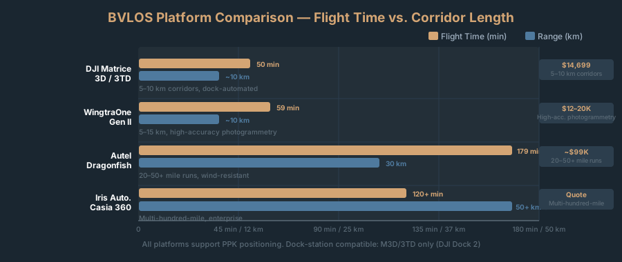
Real-world math: Under 10 miles? Matrice 3D + dock. 10–20 miles? A fixed-wing VTOL (WingtraOne or Dragonfish) needs fewer flights than a multirotor. 20–35 miles? Dragonfish: one flight of up to 180 minutes (Pro, dealer-listed maximum) can replace several multirotor flights and staging points, provided you set up the ground base station near the middle of the route. Its 30 km link range each way covers about 37 miles end to end, so longer corridors mean moving the station between flights.
The dock station (DJI Dock 2) is infrastructure, not luxury. It doesn’t swap batteries; it charges the aircraft’s battery in place, so nobody has to stand by to change packs. DJI rates the charge at about 32 minutes from 20% to 90% at 25 °C, so plan on at least a half-hour recharge between flights, and longer after a flight that lands below 20% or in cold weather. Process data in parallel while it charges.
How BVLOS Changes Your Mapping Workflows
BVLOS doesn’t change what you deliver—orthomosaics, DTMs, point clouds. It changes how fast you collect the raw data and how you structure the flight plan.
Coverage Math: BVLOS vs. VLOS
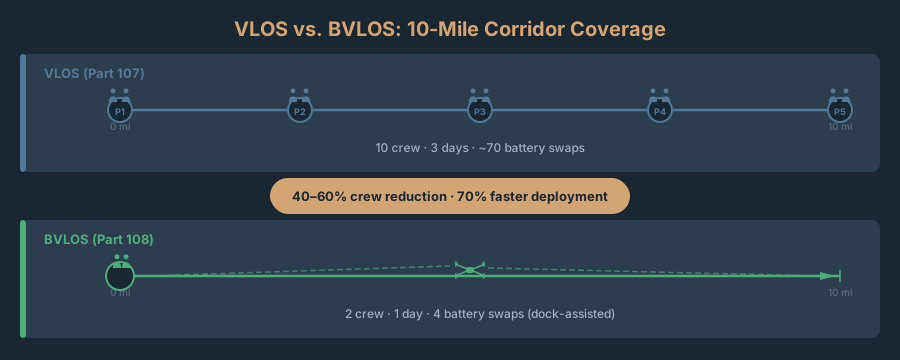
A 10-mile highway corridor. Standard VLOS workflow:
- Positions needed: 5 (roughly 2 miles / 3.2 km apart, each covering about 1 mile in either direction)
- Crew per position: 2 pilots (rotating batteries)
- Total crew: 10
- Flight time per position: ~30 minutes flying, 60 minutes ground turnaround
- Days required: 3
- Battery swaps: ~70
Same corridor with BVLOS on a Matrice 3D:
- Crew: 1 pilot plus the visual observers your waiver requires. Assume 3–5 observers along a 10-mile route, for a total crew of 4–6. (Part 108 as proposed would drop the observer requirement.)
- Flight time: 4 flights of 45 minutes each (two 5-mile legs per flight)
- Days required: 1
- Battery swaps: none. Place the DJI Dock 2 at the 5-mile midpoint so each end of the corridor is about 8 km away, inside the Dock 2’s 10 km maximum operating radius; the dock recharges the aircraft in place between the 4 flights
The math: going from 10 people to 4–6 is a 40–60% crew reduction, and going from 3 field days to 1 is about 70% faster deployment. How much that saves depends on your day rates and how much of the job is field labor; the observers and the waiver work are real costs, too.
GCP Strategy at Extended Range
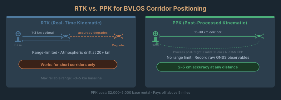
BVLOS exposes a tension in positioning strategy. At 2 km range (VLOS), you’re close enough to RTK base station corrections that you can achieve 2–5 cm XY accuracy without ground control points. At 20+ km range (BVLOS), the RTK baseline becomes unreliable—atmospheric interference and signal fade compound.
The fix: PPK (Post-Processed Kinematic) positioning.
PPK removes the need for a live correction link. Fly with high-grade GNSS (built into Matrice 3D, Dragonfish, X10), record raw observables, and process post-flight against a stationary base. You can establish that base’s own coordinates with a service such as NRCan CSRS-PPP from a long static session; kinematic PPP on the aircraft itself is looser (a CSRS-PPP kinematic test with a dual-frequency geodetic receiver reported a decimeter to a few centimeters; Journal of Navigation, 2013). PPK does not remove the baseline limit: like RTK, its error grows with distance from the base, so long corridors need bases placed along the route.
For a 15-mile corridor:
- Base station placement: 1 location, midpoint preferred. If corridor is 8+ miles from base, add a second station.
- GCP placement: 1 GCP every 200–300 meters, alternating sides. 15 miles = ~50–75 GCPs. More than VLOS, yes—but you place them once while the drone flies. With VLOS you’d do this three times.
- Processing: Import observables into Emlid Studio, tie to base station(s), bundle adjust with GCPs. Result: 2–4 cm horizontal, 3–6 cm vertical.
PPK cost: a survey-grade GNSS base, owned or rented (rental rates vary by region and receiver, so get a quote), in place of multiple staging crews. The math generally favors PPK above about 5 miles.
Fixed-Wing VTOL for Long Corridors
Over 20 miles? Switch platforms. A fixed-wing VTOL (WingtraOne, Dragonfish) cuts flight count in half.
- 15 miles on Matrice 3D: 4 flights, ~180 minutes, 2–3 days
- 15 miles on Dragonfish: 1–2 flights, 90–120 minutes, 1 day
- 30 miles on Dragonfish: 1 flight of up to 180 minutes (Pro, with the ground base station at the midpoint), 1 day
Dragonfish is expensive upfront. It earns its keep on routine 20-mile-plus surveys (utility monitoring, pipeline inspections, linear infrastructure), where fewer flights and staging points add up over a year.
The Waiver Path: Getting BVLOS Today (Before Part 108 Is Final)
If you need BVLOS capability before the final Part 108 rule, a Part 107.31 waiver is your option. The FAA publishes Waiver Safety Explanation Guidelines that list the questions a BVLOS application has to answer, so follow them closely.
The Aviation Safety Hub Submission
File your waiver application through the FAA’s Aviation Safety Hub, which has replaced DroneZone for Part 107 waiver applications (waivers submitted earlier are still processed in DroneZone). There’s no fee and no separate paper form: you answer the online application’s waiver safety explanation for §107.31 and attach supporting documentation. (FAA Form 7711-2 is the application for a certificate of waiver or authorization under other rules, such as Part 91 waivers for airshows; it isn’t the Part 107 waiver application.)
Required elements:
-
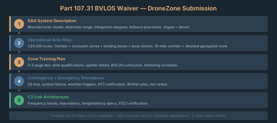
Detect and Avoid System Description. This is the hardest section. The FAA wants a detailed explanation of how your aircraft sees other traffic and avoids it. “We will use ADS-B in and pilot vigilance” is too vague. You need:
- System model, manufacturer, and specification (for example, the ADS-B In receiver or onboard detect-and-avoid sensor, its detection range and coverage).
- Performance envelope (detection range, target sizes, latency).
- Integration with your autopilot/flight control system.
- Fallback procedures if DAA fails (return to last known position, land in designated zone).
What falls short: A vague DAA description. The FAA needs spec sheets and integration diagrams—not hand-waving.
-
Operational Area Map. Show:
- Flight corridor (primary area)
- Exclusion zones (airports, helipads, restricted airspace)
- Designated landing zones (multiple options, with coordinates)
- Base station location
What falls short: A map that lacks detail. Include individual landmarks, nearby airports, specific coordinates. 15-mile corridor = 15 miles of detailed geospatial work expected.
-
Crew Training Plan. A written document covering:
- Pilot qualifications and Part 107 cert
- Spotter qualifications and duties
- BVLOS curriculum (DAA, contingencies, radio protocol)
- Retraining schedule and proficiency checks
What falls short: No formal plan. “We’ll brief the pilot” isn’t a training plan. Write a document anyone could follow.
-
Contingency and Emergency Procedures. Written plan for:
- C2 link loss and recovery
- Aircraft system failure and safe landing
- Medical emergency (pilot incapacitation)
- Weather deterioration triggers
- Authority notification (ATC, stakeholders)
-
C2 Link Architecture. How control signals and telemetry flow. Specify:
- Frequency bands (Part 107 typical: 2.4 GHz Wi-Fi 5/6)
- Redundancy (backup frequency? alternative method?)
- Range and latency specs
- FCC authorization for the radio equipment (the FAA’s guidelines ask for the FCC approval number)
Timeline
- Review time: The FAA says it will do its best to approve or disapprove waiver requests within 90 days of submission. Processing time varies with the complexity of the request and the completeness of the application.
- Requests for information: The FAA sends these through the Aviation Safety Hub. If you don’t respond within 30 days, the application is canceled and you have to resubmit.
- Revision and resubmission: The FAA disapproves applications that don’t identify operational hazards and propose mitigations, citing insufficient information. If you get a disapproval, file a revised application that addresses the FAA’s specific comments.
- Waiver validity: Set on each waiver. Check the expiration date on your certificate of waiver and plan the renewal ahead of it.
What Airspace Matters
Class G airspace (uncontrolled): Best case. Maximum flexibility. Most rural and suburban corridors are Class G.
Class D, E, C, B airspace: Requires ATC coordination (tower, center, approach). Not automatic denial, but adds layers and constraints. Some facilities approve Class D/E BVLOS with limits: operating hours, altitude floors, notification.
Class A airspace: Prohibited for BVLOS (FL180+, irrelevant for mapping).
For mapping: Class G is standard. Near a busy airport or metro area? Expect Class D/E coordination delays.
Insurance and Liability: The Threshold Problem
BVLOS exposes higher liability. Insurance follows.
Current VLOS Insurance
Standard commercial drone insurance (Part 107 VLOS) covers:
- General liability: $1–5M per occurrence, $2–10M aggregate
- Coverage: Bodily injury, property damage, personal injury
- Exclusions: Intentional acts, criminal liability, high-risk ops
- Cost: varies by fleet size, coverage limits, and claims history; get quotes
BVLOS Insurance Requirements
BVLOS = larger aircraft, longer distances, less operator proximity = higher risk. Pricing reflects that. These are market expectations, not regulatory minimums: the proposed Part 108 sets no insurance requirement for surveying operators.
- General liability: higher limits than VLOS, usually set by the client contract (utility clients tend to ask for the highest)
- Professional liability: for data delivery errors and surveying claims, if your deliverables carry them
- Coverage: Same areas as VLOS, higher limits
- Exclusions: Stricter on airspace coordination, crew training, equipment maintenance
- Cost: higher than VLOS; it depends on fleet size, waiver status, and claims history, so get quotes from aviation specialists
Finding an Insurer
Standard brokers rarely write BVLOS. Find an aviation specialist. AIG, Starr Aviation, Global Aerospace, regional carriers all write BVLOS UAS. They’ll ask for:
- Waiver proof (or a Part 108 permit once the rule is final)
- Crew training docs
- Safety management system (procedures, maintenance logs, incident reports)
- Equipment manifest and maintenance schedule
Timeline: 4–8 weeks to quote and bind. Start before flying, not after.
Cost-Benefit Math
In our 10-mile example, BVLOS cut field days from 3 to 1. Weigh that labor saving, job by job, against the extra premium your broker quotes. If you fly BVLOS corridors only once or twice a year, the premium can eat most of the saving.
What to Do Right Now
The final Part 108 rule has no published date. Here’s a preparation timeline that doesn’t depend on one:
Immediate (This Month)
-
Inventory your equipment and GNSS.
- Which platforms have standard Remote ID built in? (An add-on broadcast module won’t qualify under the proposal.)
- Do you own survey-grade GNSS base station, or will you rent?
- How many batteries fit your dock-station workflow?
-
Start insurance quotes now.
- Contact aviation brokers. Ask about BVLOS readiness and preliminary underwriting. Don’t wait for waiver approval—underwriters need lead time.
-
Read FAA docket FAA-2025-1908.
- Go to regulations.gov and read the NPRM. Understand the permit and certificate pathways and which applies to your ops.
Short Term (Next 60 Days)
-
Plan a waiver application (if you need BVLOS before Part 108 is final).
- Pick a pilot project: 5–15 mile corridor, Class G, minimal stakeholder work.
- Gather your operational area map and existing safety procedures (training, contingency).
- Draft the DAA system description and submit through the Aviation Safety Hub.
-
Dock-station procurement.
- DJI Dock 2: get a current dealer quote and lead time (and check the FCC note above).
- Check power: dock needs 100–240V AC, 50/60 Hz (verify amperage with your electrician).
-
Build crew training curriculum.
- BVLOS rules and limitations
- DAA system operation and manual override
- Visual observer responsibilities (for waiver operations)
- Radio protocol and ATC interaction
- Emergency procedures
- Plan 1–2 days in-person training per crew member.
Medium Term (Next 6 Months)
-
Execute your first BVLOS flight.
- Waiver path: launch under waiver authority.
- If Part 108 is final by then: apply for an aerial surveying permit and area approval.
-
Test real workflows.
- Run 5–10 mile corridor, compare PPK vs. RTK accuracy and cost.
- Log crew time, battery performance, weather delays.
- Refine GCP placement based on actual data.
-
Document safety systems.
- Incident reporting, maintenance logs, crew training records, equipment inventory.
- Insurers will ask for this. It also positions you ahead of competitors.
Frequently Asked Questions
Q: Once Part 108 is final, can I ignore Part 107?
A: No. As proposed, Part 107 and Part 108 coexist: Part 107 stays the standard for VLOS, and Part 108 would cover BVLOS. The proposal does not require an airman certificate for Part 108 flights; it creates two new roles instead, an operations supervisor and a flight coordinator. Your Part 107 certificate still governs every VLOS job you fly.
Q: Is RTK still viable for BVLOS, or does PPK replace it?
A: PPK is the usual choice once a corridor runs more than about 5 miles (8 km). RTK works best within 1–3 km (about 1–2 miles) of the base or on confined sites. For 10–20 mile utility work, PPK wins because you don’t need a live correction link and can place bases along the route. PPK is not range-free, though: like RTK, its accuracy degrades as the baseline grows, which is why long corridors get a second base. NTRIP networks and multiple bases stretch RTK range.
Q: Can I use a remote spotter under Part 108?
A: The proposed rule doesn’t use visual observers at all. It replaces the pilot-and-spotter model with an operations supervisor and flight coordinators, and relies on detect-and-avoid, strategic deconfliction, and right-of-way rules instead of a person watching the aircraft. A flight coordinator needs at least 5 hours of operating experience on the specific make and model, and the default is one aircraft per coordinator.
Q: What happens to my current waiver when Part 108 finalizes?
A: Nothing is final yet. The NPRM preamble says operations now conducted under waivers or exemptions would transition to Part 108 when those approvals expire and a reasonable transition can occur. The proposal would also remove BVLOS from Part 107 and delete the §107.31 waiver provision, so as proposed there would be no new or renewed Part 107 BVLOS waivers once the rule takes effect. Until a final rule publishes with actual transition dates, a current waiver remains your authority to fly BVLOS.
Q: Do I need a surveying license to deliver BVLOS-collected mapping data?
A: This depends entirely on the deliverable and your state’s regulations—not on the method of data collection. If you’re delivering a georeferenced orthomosaic or point cloud that’s used for survey-grade applications (boundary determinations, volumetric calculations, infrastructure design), your state surveying board may require licensure. BVLOS doesn’t change this. See Where the Legal Lines Are for a detailed breakdown of state regulations.
Q: Can I fly BVLOS over populated areas under Part 108?
A: Only up to a point under a permit. The proposal sorts ground risk into five population-density categories. The aerial surveying permit is limited to Category 3 or lower; Category 4 and above requires an operating certificate. Flight over open-air assemblies is prohibited on either pathway unless the FAA specifically authorizes it.
Q: How does BVLOS change my client contracts?
A: Deliverables stay the same, but your risk profile shifts. Insurance requirements increase, crew training becomes audit-able. In contracts, specify: “BVLOS operations under FAA waiver [#] or Part 108 authorization.” Detail positioning method (PPK vs. RTK), accuracy tier, limitations. Data’s the same, regulatory framework is different. Document everything.
Q: Will a drone I buy today be Part 108–compliant?
A: Unknown until the final rule publishes. As proposed, every aircraft flown under Part 108 needs an airworthiness acceptance backed by a manufacturer’s declaration of compliance, and the manufacturer must be located in the U.S. or in a country with a qualifying bilateral airworthiness agreement. No manufacturer can declare compliance with a rule that isn’t final, so don’t buy on a “Part 108–ready” promise.
BVLOS is happening now under waivers, and Part 108 was still a proposed rule, with no final rule published, as of November 2, 2026. For mapping professionals, it solves a real problem: it collapses field time from days to hours on linear infrastructure. In our 10-mile example, that’s a 40–60% smaller crew and about 70% faster data collection.
Three paths:
-
File a Part 107.31 waiver now. No fee; the FAA aims to decide within 90 days of submission, and a complete application is the best way to stay near that.
-
Prepare for Part 108. Audit equipment (Remote ID, GNSS, DAA), lock in insurance, build crew training docs. Apply for a permit once the rule lands.
-
Stay VLOS. If volume doesn’t justify the regulatory work. But watch competitors undercut you on corridor projects.
Pick based on your project pipeline and risk tolerance. Either way—move in the next 60–90 days. Operators who prepare now own this market. Operators who wait catch up from behind.
References and Further Reading
- Federal Register, NPRM “Normalizing Unmanned Aircraft Systems Beyond Visual Line of Sight Operations,” 90 FR 38212, Docket FAA-2025-1908 (published August 7, 2025).
- OIRA review status, reginfo.gov, RIN 2120-AL82.
- 49 U.S.C. 44811, Beyond visual line of sight operations for unmanned aircraft systems (added by the FAA Reauthorization Act of 2024, §930): subsection (c) sets the 16-month final-rule deadline.
- 49 U.S.C. 44807, Special authority for certain unmanned aircraft systems.
- 14 CFR 107.205, List of regulations subject to waiver.
- FCC, Report and Order FCC 26-72 (adopted October 29, 2026; released October 30, 2026), GN Docket No. 26-74, WT Docket Nos. 22-323 and 24-629, docs.fcc.gov: opens the 800 MHz Cellular band to UAS.
- FCC news release, “FCC to Modernize Rules for American Drone Dominance, Airspace Sovereignty, and Advanced Air Mobility” (October 28, 2026), docs.fcc.gov: November 19 open meeting items.
- Executive Order: “Unleashing American Drone Dominance,” June 6, 2025.
- FAA, Part 107 Waivers (last updated June 22, 2026), faa.gov/uas/commercial_operators/part_107_waivers: waiver applications now go through the Aviation Safety Hub; 90-day review goal.
- FAA, Part 107 Waiver Safety Explanation Guidelines (June 14, 2024), linked from the Part 107 Waivers page.
- DJI Dock 2 FAQ, enterprise.dji.com/dock-2/faq (charging in place, no automatic battery replacement).
Related AeroCartwright Articles
- Where the Legal Lines Are: Drone Mapping vs. Surveying
- RTK vs. PPK: Choosing Your Positioning Tier
- Drone Survey Positioning Tiers: Accuracy for Your Project
- GSD Calculator
Legal Note: BVLOS doesn’t change the mapping-vs-surveying legal framework. State surveying license requirements apply to BVLOS deliverables the same way they apply to VLOS deliverables—the method of data collection doesn’t affect the regulatory classification of the output. See Where the Legal Lines Are for details on state regulations and when a professional surveying license is required.